IMAGES TAKEN NEAR TO
Linden Grove, GATESHEAD, NE11 9BH
Introduction
This page details the photographs taken nearby to Linden Grove, NE11 9BH by members of the Geograph project.
The Geograph project started in 2005 with the aim of publishing, organising and preserving representative images for every square kilometre of Great Britain, Ireland and the Isle of Man.

There are currently over 7.5m images from over14,400 individuals and you can help contribute to the project by visiting https://www.geograph.org.uk
Image Map
Images are licensed for reuse under creativecommons.org/licenses/by-sa/2.0
Notes
- Clicking on the map will re-center to the selected point.
- The higher the marker number, the further away the image location is from the centre of the postcode.
Image Listing (43 Images Found)
Images are licensed for reuse under creativecommons.org/licenses/by-sa/2.0
Image
Details
Distance
1
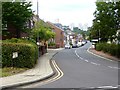
Ravensworth Road, Dunston
In the distance, beyond the River Tyne, are the tower blocks of central Newcastle.
Image: © Oliver Dixon
Taken: 24 Jul 2019
0.05 miles
2
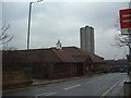
Dunston Activity Centre
Run by Gateshead Council, this is a community centre type building place where sport, keep-fit and general activities can be done.
Image: © Steve McShane
Taken: 3 Dec 2005
0.06 miles
3
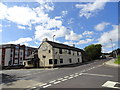
The Dun Cow, Dunston
A famous local pub which stands at the junction of Ravensworth Road with Ellison Road.
Image: © Robert Graham
Taken: 8 Aug 2012
0.06 miles
4
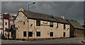
The Dun Cow
The Dun Cow public house in Dunston.
Image: © Peter McDermott
Taken: 12 Jun 2011
0.07 miles
5
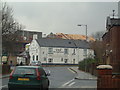
The Dun Cow
The local alehouse, on the junction of Ravensworth Road and Ellison Road.
Image: © Steve McShane
Taken: 3 Dec 2005
0.08 miles
6
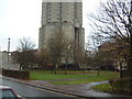
Base of the Rocket
Again, from Ravensworth Road, the lower part of the Rocket flats. Gazza learned his footie around here! See http://www.chroniclelive.co.uk/north-east-news/todays-evening-chronicle/2007/11/01/save-the-dunston-rocket-demands-gazza-72703-20044246/
Image: © Steve McShane
Taken: 3 Dec 2005
0.09 miles
8
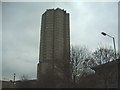
The Rocket
Dunston Rocket - view from Ravensworth Road looking north. See http://en.wikipedia.org/wiki/Dunston,_Tyne_and_Wear
Image: © Steve McShane
Taken: 3 Dec 2005
0.10 miles
9
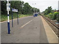
Dunston railway station, Tyne & Wear
Opened in 1909 by the North Eastern railway on the line from Newcastle to Blaydon, this station closed in 1926. It was reopened in 1984. View west towards Metrocentre and Blaydon.
Image: © Nigel Thompson
Taken: 20 Jul 2013
0.10 miles
10
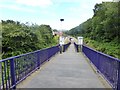
Ramp down to Dunston Station
Hourly service to Newcastle and Hexham.
Image: © Oliver Dixon
Taken: 24 Jul 2019
0.10 miles