IMAGES TAKEN NEAR TO
The Crescent, GATESHEAD, NE11 0YA
Introduction
This page details the photographs taken nearby to The Crescent, NE11 0YA by members of the Geograph project.
The Geograph project started in 2005 with the aim of publishing, organising and preserving representative images for every square kilometre of Great Britain, Ireland and the Isle of Man.

There are currently over 7.5m images from over14,400 individuals and you can help contribute to the project by visiting https://www.geograph.org.uk
Image Map
Images are licensed for reuse under creativecommons.org/licenses/by-sa/2.0
Notes
- Clicking on the map will re-center to the selected point.
- The higher the marker number, the further away the image location is from the centre of the postcode.
Image Listing (8 Images Found)
Images are licensed for reuse under creativecommons.org/licenses/by-sa/2.0
Image
Details
Distance
1
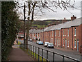
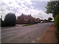
Terraced housing in Kibblesworth
Kibblesworth is a village within the boundaries of Gateshead Metropolitan Borough.
The houses in view are those of Coronation Terrace.
Image: © Trevor Littlewood
Taken: 22 Feb 2012
0.04 miles
2
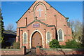
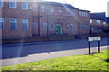
Methodist Church
The church is on Kibblesworth village main street.
Image: © peter maddison
Taken: 1 Mar 2011
0.05 miles
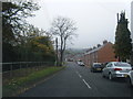
6
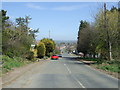
Kibblesworth Bank
Downhill into Kibblesworth.
Image: © JThomas
Taken: 2 May 2013
0.20 miles
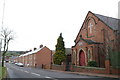
7
East end of the main street in Kibblesworth
Showing The Plough pub.
Image: © Robert Graham
Taken: 26 Apr 2011
0.21 miles
8

The Plough Public House
Kibblesworth Village
Image: © peter maddison
Taken: 1 Mar 2011
0.24 miles