IMAGES TAKEN NEAR TO
Iona Road, GATESHEAD, NE10 9TA
Introduction
This page details the photographs taken nearby to Iona Road, NE10 9TA by members of the Geograph project.
The Geograph project started in 2005 with the aim of publishing, organising and preserving representative images for every square kilometre of Great Britain, Ireland and the Isle of Man.

There are currently over 7.5m images from over14,400 individuals and you can help contribute to the project by visiting https://www.geograph.org.uk
Image Map (Loading...)


Getting Data...Please wait
Leaflet Map data © OpenStreetMap
Images are licensed for reuse under creativecommons.org/licenses/by-sa/2.0
Notes
- Clicking on the map will re-center to the selected point.
- The higher the marker number, the further away the image location is from the centre of the postcode.
Image Listing (7 Images Found)
Images are licensed for reuse under creativecommons.org/licenses/by-sa/2.0
Image
Details
Distance
4
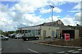
New Tesco store formerly Black House Inn
Image: © Alex McGregor
Taken: 6 Jun 2012
0.20 miles
6
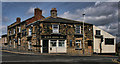
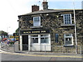
Black House Inn
The Black House Inn public house at Windy Nook in Gateshead.
Image: © Peter McDermott
Taken: 12 Jun 2011
0.21 miles
7
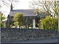
St Alban's Church, Windy Nook
Parish church, 1841-2 by Thomas Liddell, with additions 1888. A Grade II Listed Building http://list.english-heritage.org.uk/resultsingle.aspx?uid=1299810&searchtype=mapsearch
Image: © Andrew Curtis
Taken: 20 May 2012
0.22 miles