IMAGES TAKEN NEAR TO
Claremont Square, LONDON, N1 9LY
Introduction
This page details the photographs taken nearby to Claremont Square, N1 9LY by members of the Geograph project.
The Geograph project started in 2005 with the aim of publishing, organising and preserving representative images for every square kilometre of Great Britain, Ireland and the Isle of Man.

There are currently over 7.5m images from over14,400 individuals and you can help contribute to the project by visiting https://www.geograph.org.uk
Image Map
Images are licensed for reuse under creativecommons.org/licenses/by-sa/2.0
Notes
- Clicking on the map will re-center to the selected point.
- The higher the marker number, the further away the image location is from the centre of the postcode.
Image Listing (686 Images Found)
Images are licensed for reuse under creativecommons.org/licenses/by-sa/2.0
Image
Details
Distance
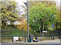
2
Amwell Street reservoir
This reservoir was originally fed from the village of Amwell in Hertfordshire, hence the name of the street. It is now fed from Stoke Newington.
Image: © Robin Hall
Taken: 21 Jan 2005
0.02 miles
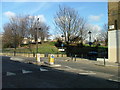
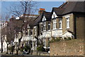
3
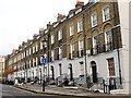
Claremont Square, N1 - southwest corner
See Image
Image: © Mike Quinn
Taken: 19 Nov 2014
0.03 miles
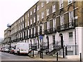
4
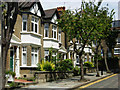
Cruikshank Street, Finsbury
These buildings have the appearance of 1920s suburban semis, but look to have been designed from the outset as flats.
Image: © Stephen McKay
Taken: 9 Jul 2009
0.03 miles
5
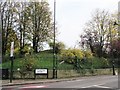
Claremont Square, N1 - northwest corner
The centre of Claremont Square is a reservoir, constructed in the early 18th C to contain water pumped up from the southern terminus of the New River at New River Head - see Image (photographed by David Hawgood). This provided a greater head of water, thereby enabling the New River Company to supply more houses, including some at higher elevations, than had previously been possible.
Image: © Mike Quinn
Taken: 19 Nov 2014
0.03 miles
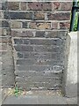
8
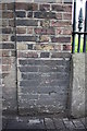
Benchmark on reservoir wall, Pentonville Road
Ordnance Survey cut mark benchmark described on the Bench Mark Database at http://www.bench-marks.org.uk/bm39321
Image: © Roger Templeman
Taken: 27 Aug 2011
0.04 miles