IMAGES TAKEN NEAR TO
Claremont Square, LONDON, N1 9LS
Introduction
This page details the photographs taken nearby to Claremont Square, N1 9LS by members of the Geograph project.
The Geograph project started in 2005 with the aim of publishing, organising and preserving representative images for every square kilometre of Great Britain, Ireland and the Isle of Man.

There are currently over 7.5m images from over14,400 individuals and you can help contribute to the project by visiting https://www.geograph.org.uk
Image Map (Loading...)


Getting Data...Please wait
Leaflet Map data © OpenStreetMap
Images are licensed for reuse under creativecommons.org/licenses/by-sa/2.0
Notes
- Clicking on the map will re-center to the selected point.
- The higher the marker number, the further away the image location is from the centre of the postcode.
Image Listing (786 Images Found)
Images are licensed for reuse under creativecommons.org/licenses/by-sa/2.0
Image
Details
Distance
1
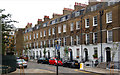
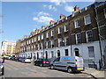
Claremont Terrace at the junction with Amwell Street
Image: © Steve Fareham
Taken: 21 Feb 2008
0.01 miles
2
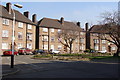
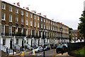
Clairmont Close
A good example of what looks to be quality social housing.
Image: © Ruth Sharville
Taken: 20 Mar 2009
0.01 miles
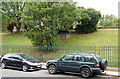
3
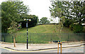
Claremont square, Islington (3)
Looking northeast at the east side of Claremont Square, Islington. The square was developed in the 1820s around the Upper Pond of the New River Company.
The New River is a man-made water channel which carried drinking water for 20 miles to London from the River Lee and Amwell Springs in Hertfordshire. It opened in 1613 and fed reservoirs in Islington. One of these, known as the Upper Pond, was built in 1709 beside Pentonville Road.
The reservoir in Claremont Square was covered and turfed in 1852 when open areas of standing water in London were prohibited by law. The reservoir is still in use by Thames Water. The semi-improved grassland on the top and sides of the reservoir supports a wide diversity of wild flowers and is a preserved habitat with restricted access. See also [http://www.geograph.org.uk/photo/1523970] and [http://www.geograph.org.uk/photo/1523973] .
Image: © Andy F
Taken: 2 Oct 2009
0.01 miles
4
Claremont square, Islington (1)
Looking at the south-east corner of Claremont Square, Islington. Claremont Square was developed in the 1820s around a reservoir, the Upper Pond, built by the New River Company.
In this view, the reservoir bank is visible through the railings.
The New River is a man-made water channel which carried drinking water for 20 miles to London from the River Lee and Amwell Springs in Hertfordshire. It opened in 1613 and fed reservoirs in Islington. One of these, known as the Upper Pond, was built in 1709 beside Pentonville Road.
The reservoir in Claremont Square was covered and turfed in 1852 when open areas of standing water in London were prohibited by law. The reservoir is still in use by Thames Water. The semi-improved grassland on the top and sides of the reservoir supports a wide diversity of wild flowers and is a preserved habitat with restricted access.
Image: © Andy F
Taken: 2 Oct 2009
0.01 miles
5
Geffrye meets his Waterloo (159)
Looking northwards up Claremont Square
Image: © Basher Eyre
Taken: 2 Apr 2016
0.01 miles
6
Claremont square, Islington (4)
Looking southwest at the south side of Claremont Square, Islington. The square was developed in the 1820s around the Upper Pond of the New River Company.
The New River is a man-made water channel which carried drinking water for 20 miles to London from the River Lee and Amwell Springs in Hertfordshire. It opened in 1613 and fed reservoirs in Islington. One of these, known as the Upper Pond, was built in 1709 beside Pentonville Road.
The reservoir in Claremont Square was covered and turfed in 1852 when open areas of standing water in London were prohibited by law. The reservoir is still in use by Thames Water. The semi-improved grassland on the top and sides of the reservoir supports a wide diversity of wild flowers and is a preserved habitat with restricted access.
In this photo, the bank of the reservoir is just visible on the right of the picture. See also [http://www.geograph.org.uk/photo/1523970] and [http://www.geograph.org.uk/photo/1523973] .
Image: © Andy F
Taken: 2 Oct 2009
0.02 miles
7
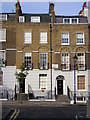
34 Claremont Square: former home of B.S. Johnson
The avant-garde writer Bryan Stanley William Johnson (1933–1973) at one time lived in a flat at 34 Claremont Square; the flat, with its view onto the square, and the surrounding area feature in several of his novels. There isn't a blue plaque, but maybe one day there will be.
Image: © Christopher Hilton
Taken: 14 Jun 2011
0.02 miles
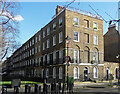
8
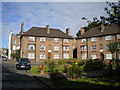
Flats on Claremont Close, Finsbury (1)
Image: © Richard Vince
Taken: 29 Jul 2017
0.02 miles
9
Claremont square, Islington (2)
Looking north in Claremont Square, Islington.
The bank visible through the railings is a reservoir, the Upper Pond, built by the New River Company. The company also developed Claremont Square in the 1820s.
The New River is a man-made water channel which carried drinking water for 20 miles to London from the River Lee and Amwell Springs in Hertfordshire. It opened in 1613 and fed reservoirs in Islington. One of these, known as the Upper Pond, was built in 1709 beside Pentonville Road.
The reservoir in Claremont Square was covered and turfed in 1852 when open areas of standing water in London were prohibited by law. The reservoir is still in use by Thames Water. The semi-improved grassland on the top and sides of the reservoir supports a wide diversity of wild flowers and is a preserved habitat with restricted access.
Image: © Andy F
Taken: 2 Oct 2009
0.02 miles
10
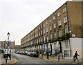
59-75 Pentonville Road
A lofty early C19th terrace, its first floor windows set in blind arches. Similar to the New River Company developments behind (e.g. Image]). Grade II listed.
Image: © Stephen Richards
Taken: 1 Mar 2015
0.02 miles