IMAGES TAKEN NEAR TO
Ramscraig Gardens, LARKHALL, ML9 3QJ
Introduction
This page details the photographs taken nearby to Ramscraig Gardens, ML9 3QJ by members of the Geograph project.
The Geograph project started in 2005 with the aim of publishing, organising and preserving representative images for every square kilometre of Great Britain, Ireland and the Isle of Man.

There are currently over 7.5m images from over14,400 individuals and you can help contribute to the project by visiting https://www.geograph.org.uk
Image Map
Images are licensed for reuse under creativecommons.org/licenses/by-sa/2.0
Notes
- Clicking on the map will re-center to the selected point.
- The higher the marker number, the further away the image location is from the centre of the postcode.
Image Listing (16 Images Found)
Images are licensed for reuse under creativecommons.org/licenses/by-sa/2.0
Image
Details
Distance
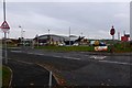
3

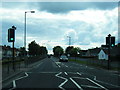
Strathaven Road, Stonehouse
Western edge of Stonehouse.
Taken to provide a windscreen free stationary version of the view - i.e. actually bothering to visit the square.
Image: © Richard Webb
Taken: 21 Apr 2014
0.15 miles
4
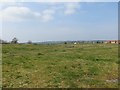
Site of the old Stonehouse Hospital
The much smaller new hospital is nearby with the old site now a big green field.
Image: © Richard Webb
Taken: 21 Apr 2014
0.16 miles
5

Site of the old Stonehouse Hospital
Stonehouse Hospital opened in the late 19th century to treat tuberculosis patients. The large Victorian buildings were demolished in 2004 and the site remains mostly undeveloped. A small hospital has been built in one corner for the treatment of elderly patients.
Image: © Richard Webb
Taken: 21 Apr 2014
0.17 miles
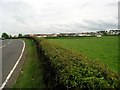
6
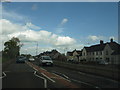
Manse Road, Stonehouse
Western edge of town.
Image: © Richard Webb
Taken: 21 Apr 2014
0.18 miles
8
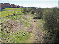
Old railway track, Stonehouse
The line was built in 1864 and originally stopped a short distance from here at Cot Castle where there were ironstone mines and limestone mines. It was extended to Strathaven in 1904. The line was closed in 1965.
Image: © wrobison
Taken: 21 Apr 2021
0.20 miles
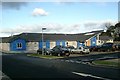
10
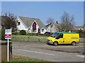
Community Hub, Stonehouse
They call this building Lifestyles.
Image: © Robert Murray
Taken: 30 Oct 2015
0.21 miles