IMAGES TAKEN NEAR TO
Stonehouse, LARKHALL, ML9 3PB
Introduction
This page details the photographs taken nearby to ML9 3PB by members of the Geograph project.
The Geograph project started in 2005 with the aim of publishing, organising and preserving representative images for every square kilometre of Great Britain, Ireland and the Isle of Man.

There are currently over 7.5m images from over14,400 individuals and you can help contribute to the project by visiting https://www.geograph.org.uk
Image Map
Images are licensed for reuse under creativecommons.org/licenses/by-sa/2.0
Notes
- Clicking on the map will re-center to the selected point.
- The higher the marker number, the further away the image location is from the centre of the postcode.
Image Listing (2 Images Found)
Images are licensed for reuse under creativecommons.org/licenses/by-sa/2.0
Image
Details
Distance
1
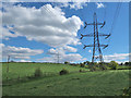
Electricity Pylons near Stonehouse
High voltage power lines crossing fields of newly cut grass. The pole on the left carries a lower voltage to supply the local farms.
Image: © wrobison
Taken: 13 May 2020
0.10 miles
2
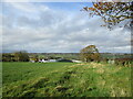
Farmland at Hazeldean
The farm in the middle ground is named Burn on older maps. Some time around the 1950s it, for some reason, became Hazeldean, with the previous Hazeldean to the east becoming East Hazeldean.
Image: © Alan O'Dowd
Taken: 25 Oct 2020
0.14 miles