IMAGES TAKEN NEAR TO
Bogside Road, LARKHALL, ML9 3AW
Introduction
This page details the photographs taken nearby to Bogside Road, ML9 3AW by members of the Geograph project.
The Geograph project started in 2005 with the aim of publishing, organising and preserving representative images for every square kilometre of Great Britain, Ireland and the Isle of Man.

There are currently over 7.5m images from over14,400 individuals and you can help contribute to the project by visiting https://www.geograph.org.uk
Image Map
Images are licensed for reuse under creativecommons.org/licenses/by-sa/2.0
Notes
- Clicking on the map will re-center to the selected point.
- The higher the marker number, the further away the image location is from the centre of the postcode.
Image Listing (8 Images Found)
Images are licensed for reuse under creativecommons.org/licenses/by-sa/2.0
Image
Details
Distance
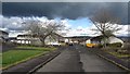
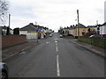
2
Bogside Road, Ashgill
At the edge of the village with electricity poles on the left and an ivy covered telephone pole on the right.
Image: © wrobison
Taken: 2 Oct 2020
0.09 miles
3
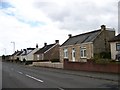
Typical Lanarkshire village houses in Ashgill
Image: © Elliott Simpson
Taken: 1 Oct 2012
0.10 miles
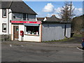
5
Crossroads in Ashgill
The road straight ahead leads through Ashgill to Netherburn. The road to the right is a local road while the road to the left leads down to the Clydeside Road.
Image: © G Laird
Taken: 29 Mar 2010
0.17 miles
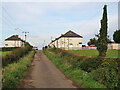
6
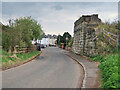
Entering Ashgill on Millburn Road
With the remains of an old railway bridge on the right. The railway connected to the many collieries in the area. It was closed in 1964.
Image: © wrobison
Taken: 15 May 2021
0.22 miles
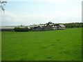
8
Over Dalserf Farm
On Netherburn Road just outside Ashgill.
Image: © G Laird
Taken: 22 Mar 2010
0.25 miles