IMAGES TAKEN NEAR TO
Cameron Park, LARKHALL, ML9 2WE
Introduction
This page details the photographs taken nearby to Cameron Park, ML9 2WE by members of the Geograph project.
The Geograph project started in 2005 with the aim of publishing, organising and preserving representative images for every square kilometre of Great Britain, Ireland and the Isle of Man.

There are currently over 7.5m images from over14,400 individuals and you can help contribute to the project by visiting https://www.geograph.org.uk
Image Map
Images are licensed for reuse under creativecommons.org/licenses/by-sa/2.0
Notes
- Clicking on the map will re-center to the selected point.
- The higher the marker number, the further away the image location is from the centre of the postcode.
Image Listing (14 Images Found)
Images are licensed for reuse under creativecommons.org/licenses/by-sa/2.0
Image
Details
Distance
1
Anderson's Garden Centre
Just off the Clydeside Road near Garrion Bridge.
Image: © G Laird
Taken: 15 Feb 2009
0.02 miles
2
The old car park at Anderson's Garden Centre - now a development opportunity
See Image for how this popular cafe and indoor grass bowling centre looked before
Image: © Elliott Simpson
Taken: 8 Oct 2012
0.03 miles
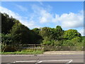
3
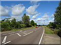
A72 towards Hamilton
From the bridge over the Mill Burn.
Image: © JThomas
Taken: 16 Sep 2021
0.08 miles
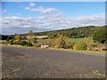
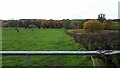
4
Woodland near Skellyton
Beside the Mill Burn.
Image: © JThomas
Taken: 16 Sep 2021
0.12 miles
5
View down to the Clyde from the Clyde Walkway
Image: © Gordon Brown
Taken: 26 Oct 2020
0.16 miles
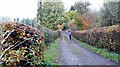
6
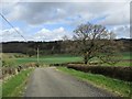
Bottom end of the Monkey Road
This track derives its nickname of The Monkey Road from the former Millburn Colliery situated near Larkhall, which was known locally as the Monkey Pit.
It provides access to the farm at Skellyton from the Lanark Road, which it reaches just beyond the bend.
Image: © Alan O'Dowd
Taken: 6 Apr 2020
0.17 miles
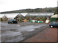
7
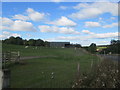
Farm buildings at Skellyton
In Lanarkshire.
Image: © James Denham
Taken: 10 Oct 2013
0.20 miles
8
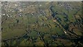
The River Clyde from the air
Dalserf is in the right foreground, with Wishaw, Gowkthrapple, Overtoun and Law in the distance.
Image: © Thomas Nugent
Taken: 19 Dec 2024
0.21 miles
9
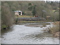
River Clyde from a Footbridge
Looking up river from Image
Image: © G Laird
Taken: 15 Feb 2009
0.22 miles