IMAGES TAKEN NEAR TO
Laurel Drive, LARKHALL, ML9 2TF
Introduction
This page details the photographs taken nearby to Laurel Drive, ML9 2TF by members of the Geograph project.
The Geograph project started in 2005 with the aim of publishing, organising and preserving representative images for every square kilometre of Great Britain, Ireland and the Isle of Man.

There are currently over 7.5m images from over14,400 individuals and you can help contribute to the project by visiting https://www.geograph.org.uk
Image Map
Images are licensed for reuse under creativecommons.org/licenses/by-sa/2.0
Notes
- Clicking on the map will re-center to the selected point.
- The higher the marker number, the further away the image location is from the centre of the postcode.
Image Listing (14 Images Found)
Images are licensed for reuse under creativecommons.org/licenses/by-sa/2.0
Image
Details
Distance
2
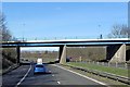
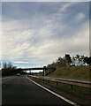
Bridge carrying the Burnhead Road over the M74
Image: © Peter Bond
Taken: 30 Sep 2011
0.07 miles
4
Junction of Hareleeshill and Keir Hardie Road
Image: © Elliott Simpson
Taken: 9 Oct 2012
0.08 miles
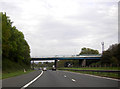
7
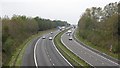
M74
Looking southwards from Burnhead Road.
Image: © Richard Webb
Taken: 24 Oct 2011
0.11 miles
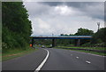
9
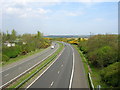
M74 Near Larkhall
The M74 passes through a gorse banked cutting near Larkhall
Image: © Iain Thompson
Taken: 6 May 2006
0.13 miles
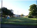
10
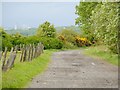
The Monkey Road
This route is signposted, at its southern end (where it leaves Burnhead Road) as '"Monkey Road" to Lanark Road'; the photo was taken not far from the wooden signpost. The unusual name is explained at Image
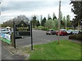
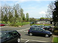
The route is about 1.85 kilometres long, with a straight-line distance of about 1.57 kilometres, and passes Millburn Cottage and Skellyton Farm (Image); at its northern end, it meets Lanark Road at a point not far from a garden centre (Image).
The tower blocks in the background are in Motherwell; my thanks to fellow Geograph contributor G Laird ( http://www.geograph.org.uk/profile/27852 ), who informs me that the wide tower block visible in the background, in the left-hand half of the photo, is Glencairn Tower.
Image: © Lairich Rig
Taken: 20 May 2005
0.17 miles