IMAGES TAKEN NEAR TO
Cameron Path, LARKHALL, ML9 2SX
Introduction
This page details the photographs taken nearby to Cameron Path, ML9 2SX by members of the Geograph project.
The Geograph project started in 2005 with the aim of publishing, organising and preserving representative images for every square kilometre of Great Britain, Ireland and the Isle of Man.

There are currently over 7.5m images from over14,400 individuals and you can help contribute to the project by visiting https://www.geograph.org.uk
Image Map
Images are licensed for reuse under creativecommons.org/licenses/by-sa/2.0
Notes
- Clicking on the map will re-center to the selected point.
- The higher the marker number, the further away the image location is from the centre of the postcode.
Image Listing (6 Images Found)
Images are licensed for reuse under creativecommons.org/licenses/by-sa/2.0
Image
Details
Distance
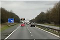
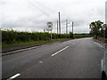
3
M74
Looking southwards from Burnhead Road.
Image: © Richard Webb
Taken: 24 Oct 2011
0.13 miles
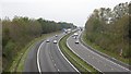
4
M74
The sign for a junction (with the A71) and a variable message sign. In Scotland these are infamous for various patronising and increasingly obscure road safety messages. Gems seen often include "COMPLY WITH RED X" and "AVOID DISTRACTIONS WHILE DRIVING". We need a "DONT TAKE PHOTOGRAPHS WHILE DRIVING" one.
Image: © Richard Webb
Taken: 24 Oct 2011
0.15 miles
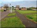
5
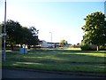
Junction of Hareleeshill and Keir Hardie Road
Image: © Elliott Simpson
Taken: 9 Oct 2012
0.18 miles
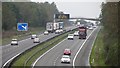
6
Shawsburn Lanarkshire
Road sign on outskirts of Shawsburn.
Image: © Gordon Dowie
Taken: 15 Jul 2010
0.24 miles