IMAGES TAKEN NEAR TO
Low Pleasance, LARKHALL, ML9 2HW
Introduction
This page details the photographs taken nearby to Low Pleasance, ML9 2HW by members of the Geograph project.
The Geograph project started in 2005 with the aim of publishing, organising and preserving representative images for every square kilometre of Great Britain, Ireland and the Isle of Man.

There are currently over 7.5m images from over14,400 individuals and you can help contribute to the project by visiting https://www.geograph.org.uk
Image Map
Images are licensed for reuse under creativecommons.org/licenses/by-sa/2.0
Notes
- Clicking on the map will re-center to the selected point.
- The higher the marker number, the further away the image location is from the centre of the postcode.
Image Listing (12 Images Found)
Images are licensed for reuse under creativecommons.org/licenses/by-sa/2.0
Image
Details
Distance
2
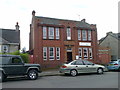
Cameronian Hall, Victoria Street
This was a drill hall during WWI - see http://canmore.rcahms.gov.uk/en/site/333032/details/larkhall+victoria+street+drill+hall/
Image: © Elliott Simpson
Taken: 8 Aug 2014
0.12 miles
3
Former 6th Battalion Scottish Rifles building
Now the Cameronian Hall, this was a drill hall during WWI - see http://canmore.rcahms.gov.uk/en/site/333032/details/larkhall+victoria+street+drill+hall/
Image: © Elliott Simpson
Taken: 8 Aug 2014
0.12 miles
4
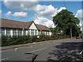
Machanhill Primary School
Part of the original building constructed in 1927.
Image: © Paul Nardone
Taken: 23 Jul 2007
0.18 miles
5
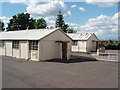
Machanhill Primary School HORSA Huts
Part of the Machanhill Primary School campus housing the kitchen and dining halls. HORSA huts were constructed circa 1947, supposedly as a short term measure (10 year lifespan!), to meet educational needs caused by buildings being destroyed in the war, the post war baby boom and the raising of the school leaving age by the 1944 Education Act (the 'Butler' Act).
HORSA = Hut Operation for the Raising of School leaving Age
Image: © Paul Nardone
Taken: 23 Jul 2007
0.18 miles
6
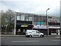
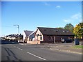
Row of shops on Larkhall Main Street
The sign for Subway is usually yellow on a green background, but not in Larkhall. Read here http://www.scotsman.com/news/nothing-about-larkhall-is-black-and-white-1-916560 for information on a sad symptom of sectarianism in the west of Scotland.
Image: © Stephen Sweeney
Taken: 23 Apr 2014
0.22 miles
7
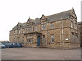
Glengowan Primary School
Built in stages between 1895 and 1903 by the then Larkhall School Board as a Secondary school. The building, its boundary walls, gatepiers and railings are c(s) listed by Historic Scotland. Due to be replaced by a new school, which is to be built in the Summerlee area of the town.
Image: © Paul Nardone
Taken: 14 Aug 2007
0.23 miles
8
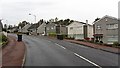
Machanhill
Larkhall residential street.
Image: © Richard Webb
Taken: 24 Oct 2011
0.23 miles
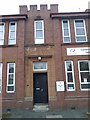
9
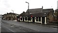
The Music Room
Bar on Church Street, Larkhall.
Image: © Richard Webb
Taken: 24 Oct 2011
0.23 miles