IMAGES TAKEN NEAR TO
Pentland Crescent, LARKHALL, ML9 1UP
Introduction
This page details the photographs taken nearby to Pentland Crescent, ML9 1UP by members of the Geograph project.
The Geograph project started in 2005 with the aim of publishing, organising and preserving representative images for every square kilometre of Great Britain, Ireland and the Isle of Man.

There are currently over 7.5m images from over14,400 individuals and you can help contribute to the project by visiting https://www.geograph.org.uk
Image Map
Images are licensed for reuse under creativecommons.org/licenses/by-sa/2.0
Notes
- Clicking on the map will re-center to the selected point.
- The higher the marker number, the further away the image location is from the centre of the postcode.
Image Listing (21 Images Found)
Images are licensed for reuse under creativecommons.org/licenses/by-sa/2.0
Image
Details
Distance
2
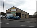
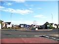
Larkhall MOT centre
On Hamilton Road.
Image: © Stephen Sweeney
Taken: 23 Apr 2014
0.15 miles
3
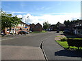
Fyne Crescent, Merryton
Towards Merryton Railway Station.
Image: © JThomas
Taken: 16 Sep 2021
0.16 miles
5
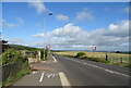
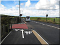
National Cycle Route 74
Beside Carlisle Road (B7078).
Image: © JThomas
Taken: 16 Sep 2021
0.20 miles
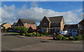
6
New Cycle Track to Ferniegair
A re-surfaced and widened pavement
Image: © wrobison
Taken: 4 Oct 2012
0.20 miles
7
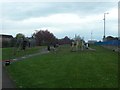
Glenview Park, Larkhall
In the north of the town.
Image: © Stephen Sweeney
Taken: 23 Apr 2014
0.22 miles