IMAGES TAKEN NEAR TO
LARKHALL, ML9 1RB
Introduction
This page details the photographs taken nearby to ML9 1RB by members of the Geograph project.
The Geograph project started in 2005 with the aim of publishing, organising and preserving representative images for every square kilometre of Great Britain, Ireland and the Isle of Man.

There are currently over 7.5m images from over14,400 individuals and you can help contribute to the project by visiting https://www.geograph.org.uk
Image Map
Images are licensed for reuse under creativecommons.org/licenses/by-sa/2.0
Notes
- Clicking on the map will re-center to the selected point.
- The higher the marker number, the further away the image location is from the centre of the postcode.
Image Listing (6 Images Found)
Images are licensed for reuse under creativecommons.org/licenses/by-sa/2.0
Image
Details
Distance
1
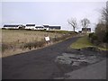
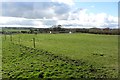
Developments at Sunnyside
This farm has developed a number of new houses - one currently for sale.
Image: © Gordon Brown
Taken: 23 Feb 2010
0.03 miles
2
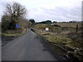
No through road
This road used to go to Millheugh Bridge and Larkhall but erosion by the River Avon has taken most of the road surface away and now it is pedestrians and cyclists only.
Image: © Gordon Brown
Taken: 23 Feb 2010
0.09 miles
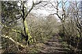
3
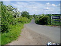
Road to Millheugh
Looking along the old road to Millheugh
Image: © Alan Pitkethley
Taken: 4 Jun 2008
0.13 miles
4
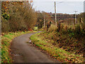
Wee Sunnyside Road
No longer in use for vehicular traffic but a good footpath/cycle path between Little Sunnyside and Millheugh Bridge. The old railway viaduct in the background was part of the Larkhall to Stonehouse line which closed in 1968.
Image: © wrobison
Taken: 12 Nov 2020
0.17 miles
5
Sunnyside
Farm on the plateau above the Avon Water.
Image: © Richard Webb
Taken: 4 Mar 2012
0.20 miles
6
Path, Chatelherault
The Avon Walkway path running along the rim of the deep gorge carrying the Avon Water.
Image: © Richard Webb
Taken: 4 Mar 2012
0.24 miles