IMAGES TAKEN NEAR TO
Craigbank Road, LARKHALL, ML9 1QF
Introduction
This page details the photographs taken nearby to Craigbank Road, ML9 1QF by members of the Geograph project.
The Geograph project started in 2005 with the aim of publishing, organising and preserving representative images for every square kilometre of Great Britain, Ireland and the Isle of Man.

There are currently over 7.5m images from over14,400 individuals and you can help contribute to the project by visiting https://www.geograph.org.uk
Image Map
Images are licensed for reuse under creativecommons.org/licenses/by-sa/2.0
Notes
- Clicking on the map will re-center to the selected point.
- The higher the marker number, the further away the image location is from the centre of the postcode.
Image Listing (5 Images Found)
Images are licensed for reuse under creativecommons.org/licenses/by-sa/2.0
Image
Details
Distance
1
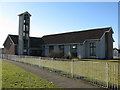
Chalmers Parish Church
On Robert Smillie Crescent, Strutherhill.
Image: © G Laird
Taken: 1 Mar 2010
0.10 miles
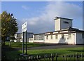
2
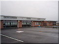
The new Craigbank Primary School
Completed in late 2008. Located in the Strutherhill area of Larkhall.
Image: © Paul Nardone
Taken: 18 Dec 2008
0.14 miles
3
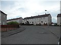
Bend on the SW corner of Glen Avenue
Just sneaking into this square.
Image: © Stephen Sweeney
Taken: 23 Apr 2014
0.19 miles
4
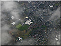
Larkhall from the air
The distinctive building is Larkhall Academy Image
Image: © Thomas Nugent
Taken: 8 Feb 2019
0.23 miles
5
Robert Smillie Primary School, Larkhall
Image: © Chris Upson
Taken: 14 Oct 2006
0.24 miles