IMAGES TAKEN NEAR TO
Millheugh Brae, LARKHALL, ML9 1AS
Introduction
This page details the photographs taken nearby to Millheugh Brae, ML9 1AS by members of the Geograph project.
The Geograph project started in 2005 with the aim of publishing, organising and preserving representative images for every square kilometre of Great Britain, Ireland and the Isle of Man.

There are currently over 7.5m images from over14,400 individuals and you can help contribute to the project by visiting https://www.geograph.org.uk
Image Map
Images are licensed for reuse under creativecommons.org/licenses/by-sa/2.0
Notes
- Clicking on the map will re-center to the selected point.
- The higher the marker number, the further away the image location is from the centre of the postcode.
Image Listing (4 Images Found)
Images are licensed for reuse under creativecommons.org/licenses/by-sa/2.0
Image
Details
Distance
1
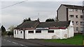
The Victory Bar
Derelict pub on MacNeil Street, Larkhall.
Image: © Richard Webb
Taken: 24 Oct 2011
0.12 miles
2
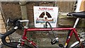
Abuse of the facilities
Dog tethering point and advert for a newspaper outside a convenience store on MacNeil Street, Larkhall.
Image: © Richard Webb
Taken: 24 Oct 2011
0.12 miles
3
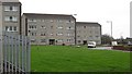
Raploch, Larkhall
Flats off Raploch Street, Larkhall.
Image: © Richard Webb
Taken: 24 Oct 2011
0.16 miles
4
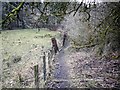
The Avon Walkway
By the River Avon (one of many in the UK - 'Avon' means 'river' so it's tautological).
Image: © Gordon Brown
Taken: 23 Feb 2010
0.22 miles