IMAGES TAKEN NEAR TO
Shawgill Court, CARLUKE, ML8 5SJ
Introduction
This page details the photographs taken nearby to Shawgill Court, ML8 5SJ by members of the Geograph project.
The Geograph project started in 2005 with the aim of publishing, organising and preserving representative images for every square kilometre of Great Britain, Ireland and the Isle of Man.

There are currently over 7.5m images from over14,400 individuals and you can help contribute to the project by visiting https://www.geograph.org.uk
Image Map
Images are licensed for reuse under creativecommons.org/licenses/by-sa/2.0
Notes
- Clicking on the map will re-center to the selected point.
- The higher the marker number, the further away the image location is from the centre of the postcode.
Image Listing (3 Images Found)
Images are licensed for reuse under creativecommons.org/licenses/by-sa/2.0
Image
Details
Distance
1

Stravenhouse Road, Law
No longer a public road, but a footpath from Law Hill to Birks Road.
Image: © Alan O'Dowd
Taken: 21 Feb 2019
0.12 miles
3
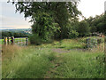
Stravenhouse Road footpath from Law to Birks Road
The old road is now a footpath. It is enclosed by trees for most of the way except for this clearing which gives a good view towards Loudoun Hill.
Image: © wrobison
Taken: 30 Jul 2022
0.18 miles