IMAGES TAKEN NEAR TO
Crossford, CARLUKE, ML8 5PY
Introduction
This page details the photographs taken nearby to ML8 5PY by members of the Geograph project.
The Geograph project started in 2005 with the aim of publishing, organising and preserving representative images for every square kilometre of Great Britain, Ireland and the Isle of Man.

There are currently over 7.5m images from over14,400 individuals and you can help contribute to the project by visiting https://www.geograph.org.uk
Image Map
Images are licensed for reuse under creativecommons.org/licenses/by-sa/2.0
Notes
- Clicking on the map will re-center to the selected point.
- The higher the marker number, the further away the image location is from the centre of the postcode.
Image Listing (6 Images Found)
Images are licensed for reuse under creativecommons.org/licenses/by-sa/2.0
Image
Details
Distance
1
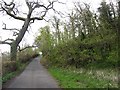
Minor road, Clydesdale
A narrow lane, near the river and beneath attractive deciduous woodland.
Image: © Richard Webb
Taken: 24 Apr 2012
0.03 miles
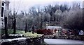
2

A Clydesdale woodland
Deciduous woodland on steep slopes, very noisy with birdsong.
Image: © Richard Webb
Taken: 24 Apr 2012
0.13 miles
5
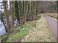
Clyde Walkway in the Spring
The snowdrops were later than usual in coming into bloom this year
Image: © Elliott Simpson
Taken: 23 Mar 2010
0.24 miles
6
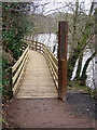
Clyde Walkway Near Crossford
New section of Clyde Walkway north of Crossford
Image: © Iain Thompson
Taken: 26 Mar 2006
0.24 miles