
IMAGES TAKEN NEAR TO
Auchenglen Road, CARLUKE, ML8 5PH
Introduction
This page details the photographs taken nearby to Auchenglen Road, ML8 5PH by members of the Geograph project.
The Geograph project started in 2005 with the aim of publishing, organising and preserving representative images for every square kilometre of Great Britain, Ireland and the Isle of Man.

There are currently over 7.5m images from over14,400 individuals and you can help contribute to the project by visiting https://www.geograph.org.uk
Image Map
Images are licensed for reuse under creativecommons.org/licenses/by-sa/2.0
Notes
- Clicking on the map will re-center to the selected point.
- The higher the marker number, the further away the image location is from the centre of the postcode.
Image Listing (4 Images Found)
Images are licensed for reuse under creativecommons.org/licenses/by-sa/2.0
Image
Details
Distance
2
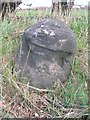
Old Milestone by the A73, Lanark Road, Braidwood, Carluke parish
Stone post by the A73, in parish of Carluke (Lanark District), South of the B7056 junction, near '30///' sign, almost opposite Garden Centre, Northeast side of road.
Inscription once read:-
(Stirling 32)
(Carlisle 78)
Surveyed
Milestone Society National ID: SL_LKAD04
Image: © Milestone Society
Taken: Unknown
0.22 miles
3
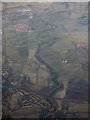
Braidwood from the air
Braidwood is to the lower left. The tree-lined course of Fiddler Burn is prominent, with part of Carluke to the top left.
Image: © Thomas Nugent
Taken: 8 Dec 2017
0.24 miles
4

Path near Braidwood
An autumnal scene on one of the paths near the village.
Image: © Alan O'Dowd
Taken: 2 Nov 2025
0.25 miles