IMAGES TAKEN NEAR TO
Stravenhouse Road, CARLUKE, ML8 5HH
Introduction
This page details the photographs taken nearby to Stravenhouse Road, ML8 5HH by members of the Geograph project.
The Geograph project started in 2005 with the aim of publishing, organising and preserving representative images for every square kilometre of Great Britain, Ireland and the Isle of Man.

There are currently over 7.5m images from over14,400 individuals and you can help contribute to the project by visiting https://www.geograph.org.uk
Image Map
Images are licensed for reuse under creativecommons.org/licenses/by-sa/2.0
Notes
- Clicking on the map will re-center to the selected point.
- The higher the marker number, the further away the image location is from the centre of the postcode.
Image Listing (8 Images Found)
Images are licensed for reuse under creativecommons.org/licenses/by-sa/2.0
Image
Details
Distance
2
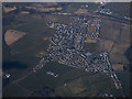
Law from the air
Birks Farm is in the foreground.
Image: © Thomas Nugent
Taken: 19 Mar 2018
0.15 miles
3
Quarter Turn on Birks Road, near Law
A relatively wide road for an unclassified road where 2 cars can pass quite easily.
Image: © G Laird
Taken: 27 Oct 2010
0.15 miles
4
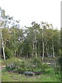
Colliery waste, Birks Road
Birches growing on a bing. There are a lot of remnants from coal mining days here.
Image: © Richard Webb
Taken: 24 Sep 2010
0.17 miles
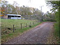
5
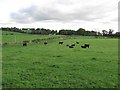
Grassland off Birks Road
Aberdeen Angus cattle at Law.
Image: © Richard Webb
Taken: 24 Sep 2010
0.17 miles
6
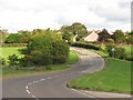
Brownlee Road, Law
B7011 climbs to Law from the Clyde.
Image: © Richard Webb
Taken: 24 Sep 2010
0.20 miles
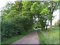
7
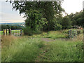
Stravenhouse Road footpath from Law to Birks Road
The old road is now a footpath. It is enclosed by trees for most of the way except for this clearing which gives a good view towards Loudoun Hill.
Image: © wrobison
Taken: 30 Jul 2022
0.21 miles
8
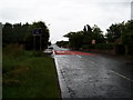
Brownlee Road Law
Taken on a very dull and wet 15th July.
Image: © Gordon Dowie
Taken: 15 Jul 2010
0.24 miles