IMAGES TAKEN NEAR TO
Quarry Road, CARLUKE, ML8 5HB
Introduction
This page details the photographs taken nearby to Quarry Road, ML8 5HB by members of the Geograph project.
The Geograph project started in 2005 with the aim of publishing, organising and preserving representative images for every square kilometre of Great Britain, Ireland and the Isle of Man.

There are currently over 7.5m images from over14,400 individuals and you can help contribute to the project by visiting https://www.geograph.org.uk
Image Map
Images are licensed for reuse under creativecommons.org/licenses/by-sa/2.0
Notes
- Clicking on the map will re-center to the selected point.
- The higher the marker number, the further away the image location is from the centre of the postcode.
Image Listing (5 Images Found)
Images are licensed for reuse under creativecommons.org/licenses/by-sa/2.0
Image
Details
Distance
1
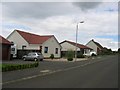
Law Hill
New houses on the site of a triangulation pillar.
Image: © Richard Webb
Taken: 1 Jul 2004
0.06 miles
2
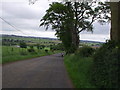
Law Hill
Lawhill Road has some lovely beech trees near the top. We have our backs to Law and Carluke is ahead.
Image: © Jennifer Romero
Taken: 27 Jun 2005
0.11 miles
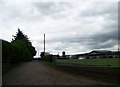
3

Quarry Road, Law Hill
An old farm road leading uphill into a modern residential development in the village of Law.
Image: © Alan O'Dowd
Taken: 21 Feb 2019
0.16 miles
5

Stravenhouse Road, Law
No longer a public road, but a footpath from Law Hill to Birks Road.
Image: © Alan O'Dowd
Taken: 21 Feb 2019
0.23 miles