IMAGES TAKEN NEAR TO
Law, CARLUKE, ML8 5EY
Introduction
This page details the photographs taken nearby to ML8 5EY by members of the Geograph project.
The Geograph project started in 2005 with the aim of publishing, organising and preserving representative images for every square kilometre of Great Britain, Ireland and the Isle of Man.

There are currently over 7.5m images from over14,400 individuals and you can help contribute to the project by visiting https://www.geograph.org.uk
Image Map
Images are licensed for reuse under creativecommons.org/licenses/by-sa/2.0
Notes
- Clicking on the map will re-center to the selected point.
- The higher the marker number, the further away the image location is from the centre of the postcode.
Image Listing (9 Images Found)
Images are licensed for reuse under creativecommons.org/licenses/by-sa/2.0
Image
Details
Distance
1
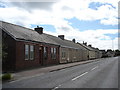
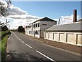
Miners' Row, Wildmanbridge, Law
Former miners' row now refurbished to provide excellent housing.
Image: © paul birrell
Taken: 9 Aug 2006
0.12 miles
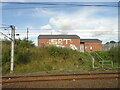
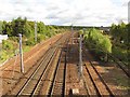
3
Caledonian Railway / West Coast Mainline
Railway running north, passing Law, Lanarkshire.
Image: © Richard Webb
Taken: 24 Sep 2010
0.16 miles
4
Footbridge over the Garrion Burn, Law
There are notices to say the bridge has been closed for safety reasons.
Image: © wrobison
Taken: 6 Aug 2022
0.18 miles
5
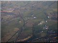
Wildmanbridge from the air
The Garrion Burn runs around the lower right corner of the photo.
Image: © Thomas Nugent
Taken: 8 Dec 2017
0.19 miles
6
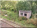
Platelayer's hut, Law
Ruined trackside hut and disused siding.
Image: © Richard Webb
Taken: 24 Sep 2010
0.19 miles
8
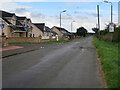
Waterlands Road, Law
On the route of the Old Wishaw Road from Law to Carluke.
Image: © wrobison
Taken: 6 Aug 2022
0.22 miles
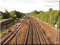
9
West Coast Mainline
Southward view, passing Law.
Image: © Richard Webb
Taken: 24 Sep 2010
0.23 miles