IMAGES TAKEN NEAR TO
CARLUKE, ML8 4QZ
Introduction
This page details the photographs taken nearby to ML8 4QZ by members of the Geograph project.
The Geograph project started in 2005 with the aim of publishing, organising and preserving representative images for every square kilometre of Great Britain, Ireland and the Isle of Man.

There are currently over 7.5m images from over14,400 individuals and you can help contribute to the project by visiting https://www.geograph.org.uk
Image Map
Images are licensed for reuse under creativecommons.org/licenses/by-sa/2.0
Notes
- Clicking on the map will re-center to the selected point.
- The higher the marker number, the further away the image location is from the centre of the postcode.
Image Listing (5 Images Found)
Images are licensed for reuse under creativecommons.org/licenses/by-sa/2.0
Image
Details
Distance
1
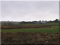
Easterseat Farm, from the track to the Spingfield Fishery
Image: © M J Richardson
Taken: 5 Jan 2008
0.01 miles
2
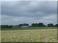
Easterseat Farm with wind turbines in the background
Between Forth and Carluke this landscape has varied land uses farming, a former reservoir (unseen) which is now a fish farm, old mine workings and a huge windfarm covering many grid squares between Carluke and Forth and visible from a wide area.
Image: © paul birrell
Taken: 11 Jun 2006
0.04 miles
3
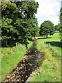
Netherton Burn
Netherton Burn flows through Springfield Reservoir. This photograph shows the section of the burn just south of Springfield Reservoir.
Image: © G Laird
Taken: 10 Sep 2013
0.07 miles
4
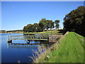
Dam and intake at Springfield Reservoir
Once a water supply for Motherwell Town Council, this is now a fishing loch.
Image: © Alan O'Dowd
Taken: 20 Sep 2019
0.07 miles
5
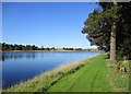
Springfield Reservoir
Formerly a water supply for Motherwell Town Council, and now a fishing loch.
Some of the turbines of the Black Law Windfarm are visible in the distance.
Image: © Alan O'Dowd
Taken: 20 Sep 2019
0.10 miles