IMAGES TAKEN NEAR TO
Carrick Gardens, CARLUKE, ML8 4PD
Introduction
This page details the photographs taken nearby to Carrick Gardens, ML8 4PD by members of the Geograph project.
The Geograph project started in 2005 with the aim of publishing, organising and preserving representative images for every square kilometre of Great Britain, Ireland and the Isle of Man.

There are currently over 7.5m images from over14,400 individuals and you can help contribute to the project by visiting https://www.geograph.org.uk
Image Map
Images are licensed for reuse under creativecommons.org/licenses/by-sa/2.0
Notes
- Clicking on the map will re-center to the selected point.
- The higher the marker number, the further away the image location is from the centre of the postcode.
Image Listing (5 Images Found)
Images are licensed for reuse under creativecommons.org/licenses/by-sa/2.0
Image
Details
Distance

2
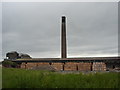
Mayfield Brickworks, Carluke
At one time there were several of these brickworks utilising colliery waste to produce bricks. I think this is the only one still operating in the Carluke area.
Image: © paul birrell
Taken: 11 Jun 2006
0.22 miles
3
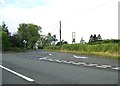
Parallel roads
Wilton Road on left, Elderslea Road on right
Image: © Jim Smillie
Taken: 23 Jul 2021
0.23 miles
4
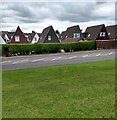
Houses backing on to Lanark Road
When we passed by here as youngsters we called these the hen houses
Image: © Jim Smillie
Taken: 14 May 2021
0.24 miles