IMAGES TAKEN NEAR TO
Glenmavis Crescent, CARLUKE, ML8 4JL
Introduction
This page details the photographs taken nearby to Glenmavis Crescent, ML8 4JL by members of the Geograph project.
The Geograph project started in 2005 with the aim of publishing, organising and preserving representative images for every square kilometre of Great Britain, Ireland and the Isle of Man.

There are currently over 7.5m images from over14,400 individuals and you can help contribute to the project by visiting https://www.geograph.org.uk
Image Map
Images are licensed for reuse under creativecommons.org/licenses/by-sa/2.0
Notes
- Clicking on the map will re-center to the selected point.
- The higher the marker number, the further away the image location is from the centre of the postcode.
Image Listing (5 Images Found)
Images are licensed for reuse under creativecommons.org/licenses/by-sa/2.0
Image
Details
Distance
1
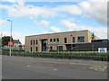
St Athanasius' Primary School
One of the schools in Carluke that is newly built, at least one other is currently under construction. Taken on a day when mergers and closures of South Lanarkshire schools was a news item.
Image: © Richard Webb
Taken: 24 Sep 2010
0.19 miles
2
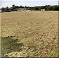
Crawforddyke recreation ground
The grass has been mown recently. Skate park in neighbouring square.
Image: © Jim Smillie
Taken: 23 Jul 2021
0.21 miles
3
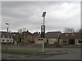
Solar powered flashers
A residential area of Carluke, near the school, with "flashing nanny" signs. These are powered by solar panels held high above easy ned access height. They would have been struggling to power up on this dark day.
Image: © Richard Webb
Taken: 29 Mar 2008
0.23 miles
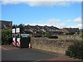
4

United Reformed Church: Carluke
Just off roundabout on Carnwath Road
Image: © Jim Smillie
Taken: 23 Jul 2021
0.23 miles
5
Clothing recycling
Clothes bins in a corner of a car park, Carluke.
Image: © Richard Webb
Taken: 24 Sep 2010
0.23 miles