IMAGES TAKEN NEAR TO
Stonedyke Crescent, CARLUKE, ML8 4EY
Introduction
This page details the photographs taken nearby to Stonedyke Crescent, ML8 4EY by members of the Geograph project.
The Geograph project started in 2005 with the aim of publishing, organising and preserving representative images for every square kilometre of Great Britain, Ireland and the Isle of Man.

There are currently over 7.5m images from over14,400 individuals and you can help contribute to the project by visiting https://www.geograph.org.uk
Image Map
Images are licensed for reuse under creativecommons.org/licenses/by-sa/2.0
Notes
- Clicking on the map will re-center to the selected point.
- The higher the marker number, the further away the image location is from the centre of the postcode.
Image Listing (5 Images Found)
Images are licensed for reuse under creativecommons.org/licenses/by-sa/2.0
Image
Details
Distance
1
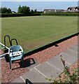
Bowling Green
At Castlehill Bowling Club Carluke
Image: © Jim Smillie
Taken: 23 Jul 2021
0.08 miles
2
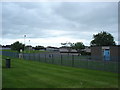
Carluke Primary School
On east side of town built in the 1970's to accommodate an expanding population.
Image: © paul birrell
Taken: 11 Jun 2006
0.12 miles
3
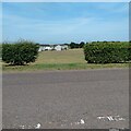
Gap in the hedge
Allowing access to Stonedyke playing fields
Image: © Jim Smillie
Taken: 23 Jul 2021
0.13 miles
4
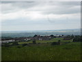
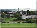
Moor Park ,Carluke from Yieldshields Road
Playing fields and housing on eastern edge of town
Image: © paul birrell
Taken: 11 Jun 2006
0.20 miles