
IMAGES TAKEN NEAR TO
Polkemmet Drive, SHOTTS, ML7 5RD
Introduction
This page details the photographs taken nearby to Polkemmet Drive, ML7 5RD by members of the Geograph project.
The Geograph project started in 2005 with the aim of publishing, organising and preserving representative images for every square kilometre of Great Britain, Ireland and the Isle of Man.

There are currently over 7.5m images from over14,400 individuals and you can help contribute to the project by visiting https://www.geograph.org.uk
Image Map
Images are licensed for reuse under creativecommons.org/licenses/by-sa/2.0
Notes
- Clicking on the map will re-center to the selected point.
- The higher the marker number, the further away the image location is from the centre of the postcode.
Image Listing (3 Images Found)
Images are licensed for reuse under creativecommons.org/licenses/by-sa/2.0
Image
Details
Distance
1

Approaching Harthill
This used to be the main Edinburgh - Glasgow road and it appears that it was a dual carriageway with one half now grassed over. Instead of four lanes, now it is a B road, narrowed by traffic calming measures.
Image: © Richard Webb
Taken: 13 Jun 2008
0.23 miles
2
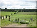
Farmland, Greenrigg
View southwards over the young River Almond from the B7066 at Greenrigg.
Image: © Richard Webb
Taken: 13 Jun 2008
0.24 miles
3
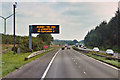
Variable Message Sign (VMS) on the M8 near to Harthill
A variable message sign on the eastbound carriageway of the M8 near to Harthill in North Lanarkshire.
Variable message signs (VMS), also sometimes referred to as matrix signs, are electronic traffic signs used on motorways (and some other major routes) to give drivers information about special events and to warn them about traffic congestion, accidents, incidents, roadworks or speed limits on specific sections of the route. They may also suggest (or instruct) drivers to take alternative routes, limit speed, warn of duration and location of the incidents or just inform of the traffic conditions. The large VMS ahead is giving drivers an estimation of how long it is likely to take for them to reach Junction 3 (Livingston) and the junction with the M9 (and hence gives an idea of how congested the motorway is ahead).
Image: © David Dixon
Taken: 3 Aug 2019
0.24 miles