IMAGES TAKEN NEAR TO
Burns Crescent, SHOTTS, ML7 5QY
Introduction
This page details the photographs taken nearby to Burns Crescent, ML7 5QY by members of the Geograph project.
The Geograph project started in 2005 with the aim of publishing, organising and preserving representative images for every square kilometre of Great Britain, Ireland and the Isle of Man.

There are currently over 7.5m images from over14,400 individuals and you can help contribute to the project by visiting https://www.geograph.org.uk
Image Map
Images are licensed for reuse under creativecommons.org/licenses/by-sa/2.0
Notes
- Clicking on the map will re-center to the selected point.
- The higher the marker number, the further away the image location is from the centre of the postcode.
Image Listing (4 Images Found)
Images are licensed for reuse under creativecommons.org/licenses/by-sa/2.0
Image
Details
Distance
1
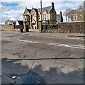
Viewfield House
Dating from 1872 this has been a hotel, masonic hall as well as a private home
Image: © Jim Smillie
Taken: 11 May 2021
0.14 miles
2
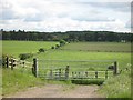
Farmland, Greenrigg
View southwards over the young River Almond from the B7066 at Greenrigg.
Image: © Richard Webb
Taken: 13 Jun 2008
0.19 miles
3
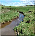
River Almond
Just east of Harthill-Fauldhouse Road
Image: © Jim Smillie
Taken: 11 May 2021
0.20 miles
4
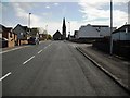
Westcraigs Road
Forrest Memorial Hall at junction with West and East Main Street
Image: © Jim Smillie
Taken: 14 May 2009
0.21 miles