IMAGES TAKEN NEAR TO
Benhar Road, SHOTTS, ML7 5EP
Introduction
This page details the photographs taken nearby to Benhar Road, ML7 5EP by members of the Geograph project.
The Geograph project started in 2005 with the aim of publishing, organising and preserving representative images for every square kilometre of Great Britain, Ireland and the Isle of Man.

There are currently over 7.5m images from over14,400 individuals and you can help contribute to the project by visiting https://www.geograph.org.uk
Image Map
Images are licensed for reuse under creativecommons.org/licenses/by-sa/2.0
Notes
- Clicking on the map will re-center to the selected point.
- The higher the marker number, the further away the image location is from the centre of the postcode.
Image Listing (4 Images Found)
Images are licensed for reuse under creativecommons.org/licenses/by-sa/2.0
Image
Details
Distance
1
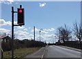
Bridge over the railway at Shotts
Single-track bridge controlled by traffic lights.
Image: © Barbara Carr
Taken: 30 Apr 2013
0.07 miles
2
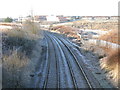
Railway in the outskirts of Shotts
Looking west in the direction of Shotts Railway Station.
Image: © G Laird
Taken: 29 Nov 2012
0.09 miles
3
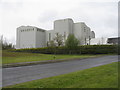
Davidson's Animal Feeds, Shotts
A large animal feed mill.
Image: © M J Richardson
Taken: 17 May 2012
0.18 miles
4

Shotts Iron Works
Behind the Boys Brigade parade in Calderhead School playground here can be seen the long-ago demolished buildings that formed part of the foundry alongside the blast furnaces of the Shotts Iron Works.
Image: © James Allan
Taken: Unknown
0.24 miles