IMAGES TAKEN NEAR TO
Rosehall Road, SHOTTS, ML7 5BS
Introduction
This page details the photographs taken nearby to Rosehall Road, ML7 5BS by members of the Geograph project.
The Geograph project started in 2005 with the aim of publishing, organising and preserving representative images for every square kilometre of Great Britain, Ireland and the Isle of Man.

There are currently over 7.5m images from over14,400 individuals and you can help contribute to the project by visiting https://www.geograph.org.uk
Image Map
Images are licensed for reuse under creativecommons.org/licenses/by-sa/2.0
Notes
- Clicking on the map will re-center to the selected point.
- The higher the marker number, the further away the image location is from the centre of the postcode.
Image Listing (8 Images Found)
Images are licensed for reuse under creativecommons.org/licenses/by-sa/2.0
Image
Details
Distance
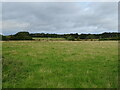
1
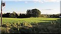
Field, Dykehead
Typical of the area, a grass field.
Image: © Richard Webb
Taken: 24 Sep 2010
0.05 miles
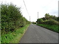
3
Low bridge
On Rosehall Road, west of Shotts station
Image: © Jim Smillie
Taken: 12 Oct 2009
0.11 miles
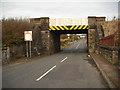
4
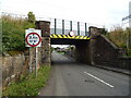
Low railway bridge over Rosehall Road, Dykehead
Image: © JThomas
Taken: 17 Sep 2021
0.12 miles
5
Grazing, Dykehead
Towards the distant railway line from Glasgow Central to Edinburgh Waverley via Shotts.
Image: © JThomas
Taken: 17 Sep 2021
0.12 miles
6
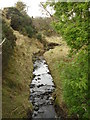
Tributary of the South Calder
On the north side of Rosehall Road near Shotts.
Image: © Jim Smillie
Taken: 12 Oct 2009
0.23 miles
7
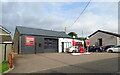
Service station, Dykehead
Rosehall Garage on Rosehall Road.
Image: © JThomas
Taken: 17 Sep 2021
0.23 miles
8
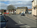
Dykehead cross
This is the 'centre' of Dykehead, but the centre of Shotts lies about a mile behind the camera position
Image: © James Allan
Taken: 10 Apr 2006
0.24 miles