IMAGES TAKEN NEAR TO
Kirkview Avenue, SHOTTS, ML7 4NE
Introduction
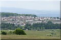
This page details the photographs taken nearby to Kirkview Avenue, ML7 4NE by members of the Geograph project.
The Geograph project started in 2005 with the aim of publishing, organising and preserving representative images for every square kilometre of Great Britain, Ireland and the Isle of Man.

There are currently over 7.5m images from over14,400 individuals and you can help contribute to the project by visiting https://www.geograph.org.uk
Image Map
Images are licensed for reuse under creativecommons.org/licenses/by-sa/2.0
Notes
- Clicking on the map will re-center to the selected point.
- The higher the marker number, the further away the image location is from the centre of the postcode.
Image Listing (20 Images Found)
Images are licensed for reuse under creativecommons.org/licenses/by-sa/2.0
Image
Details
Distance
1
Pedestrian barrier, Salsburgh
The village is split by the old A8 road, still busy now with quarry traffic. The grass strip on the other side was once the road when it was wider in the days before the motorway.
Image: © Richard Webb
Taken: 20 Mar 2009
0.02 miles
2
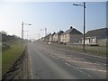
Glasgow and Edinburgh Road, Salsburgh
The old 3 lane A8, now slimmed down to a normal 2 lane road, with most traffic running by on the M8 motorway. Due to the quarries and opencast mines in the area, this is still a busy road.
Image: © Richard Webb
Taken: 20 Mar 2009
0.04 miles
3
B7066 through Salsburgh
View from replacement bridge opened in 2014. Image
At that time the road's alignment was altered slightly.
Image: © Jim Smillie
Taken: 8 Jan 2021
0.08 miles
4

Wet meadow
Formerly used for grazing cattle but has been untouched for many years
Image: © Jim Smillie
Taken: 9 Jul 2020
0.13 miles
5
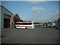
Muirhall Garage
Business started in 1926, the name Golden Eagle Coaches dates from 1935 when the company bought its first coach for tours.
Image: © Jim Smillie
Taken: 16 Apr 2009
0.14 miles
6

Salsburgh Gospel Hall
A small gospel hall in the centre of Salsburgh.
Image: © G Laird
Taken: 18 Jun 2012
0.14 miles
8

Shotts Burn: Between the 'Glenbrae' and the 'new road'
This part of Main Street is known as the Glenbrae and older residents of the village refer to the former A8 as the 'new road' (1930)
Image: © Jim Smillie
Taken: 16 Jul 2020
0.18 miles
9

Over or across
The central section of the footbridge which was knocked down has been temporarily replaced.
However due to public pressure, a controlled crossing and reduced speed limit has been introduced.
Image: © Jim Smillie
Taken: 26 Jul 2009
0.18 miles
10

Shotts Burn
Flowing from under B7066 (former A8). The tunnel dates from the construction of Glasgow-Edinburgh Road (1930)
Image: © Jim Smillie
Taken: 16 Jul 2020
0.18 miles