IMAGES TAKEN NEAR TO
Shottskirk Road, SHOTTS, ML7 4ER
Introduction
This page details the photographs taken nearby to Shottskirk Road, ML7 4ER by members of the Geograph project.
The Geograph project started in 2005 with the aim of publishing, organising and preserving representative images for every square kilometre of Great Britain, Ireland and the Isle of Man.

There are currently over 7.5m images from over14,400 individuals and you can help contribute to the project by visiting https://www.geograph.org.uk
Image Map
Images are licensed for reuse under creativecommons.org/licenses/by-sa/2.0
Notes
- Clicking on the map will re-center to the selected point.
- The higher the marker number, the further away the image location is from the centre of the postcode.
Image Listing (9 Images Found)
Images are licensed for reuse under creativecommons.org/licenses/by-sa/2.0
Image
Details
Distance
1

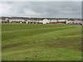
View Across Fields To Shotts
View across fields to Shotts, with Blacklaw Windfarm on the hills behind. Taken from the Hirst Road on the B7066.
Image: © Andrew MacKinnon
Taken: 13 Jun 2006
0.12 miles
2
Dykehead
Looking south towards Dykehead Cross
Image: © James Allan
Taken: 10 Apr 2006
0.13 miles
3

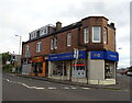
Hannah Park, Shotts
Home of Shotts Bon Accord, Junior Football Club
Image: © Robert Guthrie
Taken: 28 Apr 2007
0.19 miles
4

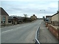
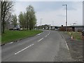
Road Bridge across Curry Burn
Looking along Shottskirk Road in the direction of Shotts town centre.
Image: © G Laird
Taken: 29 Nov 2012
0.19 miles
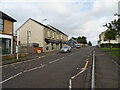
6
Houses at Burnside Crescent, Shotts
Looking across a wet football field by Calderhead Road.
Image: © M J Richardson
Taken: 17 May 2012
0.23 miles
7
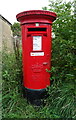
Postbox on Shottskirk Road, Shotts
Postbox No. ML7 100.
Image: © JThomas
Taken: 17 Sep 2021
0.24 miles
9
Calderhead Road
Running through an industrial estate on former colliery land.
Image: © Richard Webb
Taken: 24 Apr 2009
0.25 miles