IMAGES TAKEN NEAR TO
Woodside Drive, AIRDRIE, ML6 9TL
Introduction
This page details the photographs taken nearby to Woodside Drive, ML6 9TL by members of the Geograph project.
The Geograph project started in 2005 with the aim of publishing, organising and preserving representative images for every square kilometre of Great Britain, Ireland and the Isle of Man.

There are currently over 7.5m images from over14,400 individuals and you can help contribute to the project by visiting https://www.geograph.org.uk
Image Map
Images are licensed for reuse under creativecommons.org/licenses/by-sa/2.0
Notes
- Clicking on the map will re-center to the selected point.
- The higher the marker number, the further away the image location is from the centre of the postcode.
Image Listing (13 Images Found)
Images are licensed for reuse under creativecommons.org/licenses/by-sa/2.0
Image
Details
Distance
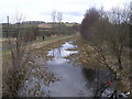
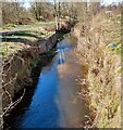
2

Monkland Canal near Calderbank
Near the start of the canal at the water intake from the North Calder Water.
Image: © wrobison
Taken: 26 Oct 2024
0.14 miles
3
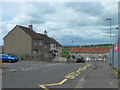
Crowwood Crescent, Calderbank
Outside Corpus Christi Primary School.
Image: © Stephen Sweeney
Taken: 14 May 2014
0.15 miles
4
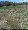
Former cricket ground
This was the home of Woodhall Cricket Club
Image: © Jim Smillie
Taken: 12 Apr 2021
0.16 miles
5
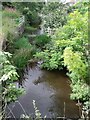
The Monkland Canal Eastern Terminus
The beginning of the canal at Calderbank - in the sense that this is where the water that fills it enters it.
Image: © Robert Murray
Taken: 24 Aug 2009
0.18 miles
6
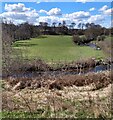
Field in meander loop
North Calder west of Calderbank
Image: © Jim Smillie
Taken: 12 Apr 2021
0.19 miles
7
Monkland Canal
The start of the canal, though abandoned for navigation in 1942.
Image: © G Laird
Taken: 6 Aug 2011
0.20 miles
8
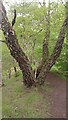
Some Mad Bark
If ever I get famous in later life (highly unlikely), or posthumously (even more unlikely!), people may in the future study my submissions of the coming months and correctly assume I was going through a 'tree phase' at the time. Since I spend a lot of my time wandering around the countryside I have decided it is high time I at least attain a basic proficiency in tree identification.
Despite there being only around 80 species of trees (about 55 of which are designated as 'native') appearing in the wild, it is not as easy as I hoped. This scaly specimen is a case in point. I am 95% certain it is an old silver birch (people I have shown the picture to, though, are not convinced), because a) it looked like silver birch bark further up, and b) there is an obvious thin birch growing up from the middle of its split trunk. Online pictures of old silver birch do show trunks approaching this state, but none quite as pronounced.
Whatever it is, it is certainly eye-catching. There are a number of good paths around here. Despite the fact that you can hear traffic all the time from the nearby old A8 bit of the M8 (which is now no longer a connecting part of the motorway, but still in heavy use) this is definitely an area well worth a visit, which still has a very rural feel.
Image: © Ian Dodds
Taken: 21 May 2022
0.21 miles
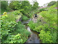
9
Canal feeder
Water from the North Calder was diverted into the Monkland Canal here
Image: © Jim Smillie
Taken: 12 Apr 2021
0.22 miles
10
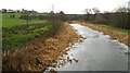
Monkland Canal
Built in the late 18th century to carry coal to Glasgow from the Lanarkshire coalfield. After nearly a fortnight of relatively mild weather, the ice is still present from the New Year cold spell.
Image: © Richard Webb
Taken: 22 Jan 2010
0.23 miles