IMAGES TAKEN NEAR TO
Hillfoot Road, AIRDRIE, ML6 9PW
Introduction
This page details the photographs taken nearby to Hillfoot Road, ML6 9PW by members of the Geograph project.
The Geograph project started in 2005 with the aim of publishing, organising and preserving representative images for every square kilometre of Great Britain, Ireland and the Isle of Man.

There are currently over 7.5m images from over14,400 individuals and you can help contribute to the project by visiting https://www.geograph.org.uk
Image Map
Images are licensed for reuse under creativecommons.org/licenses/by-sa/2.0
Notes
- Clicking on the map will re-center to the selected point.
- The higher the marker number, the further away the image location is from the centre of the postcode.
Image Listing (2 Images Found)
Images are licensed for reuse under creativecommons.org/licenses/by-sa/2.0
Image
Details
Distance
1
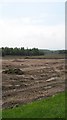
Land under development, Gartlea
Probably an extension to Brownsburn Industrial Estate.
Image: © Richard Webb
Taken: 25 Jul 2008
0.17 miles
2
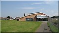
Gartlea Community Centre
Recently built to replace a building which went on fire in 2001.
Image: © Richard Webb
Taken: 25 Jul 2008
0.17 miles