IMAGES TAKEN NEAR TO
Abbotsford Road, AIRDRIE, ML6 8XJ
Introduction
This page details the photographs taken nearby to Abbotsford Road, ML6 8XJ by members of the Geograph project.
The Geograph project started in 2005 with the aim of publishing, organising and preserving representative images for every square kilometre of Great Britain, Ireland and the Isle of Man.

There are currently over 7.5m images from over14,400 individuals and you can help contribute to the project by visiting https://www.geograph.org.uk
Image Map
Images are licensed for reuse under creativecommons.org/licenses/by-sa/2.0
Notes
- Clicking on the map will re-center to the selected point.
- The higher the marker number, the further away the image location is from the centre of the postcode.
Image Listing (4 Images Found)
Images are licensed for reuse under creativecommons.org/licenses/by-sa/2.0
Image
Details
Distance
1
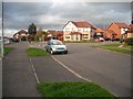
Rockcliffe Path
New housing, Chapelhall.
Image: © Richard Webb
Taken: 4 Oct 2009
0.22 miles
3
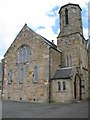
Chapelhall Parish Church
A difficult church to photograph, being closely surrounded by other buildings. 2 more distant views can be seen in the Chapelhall Parish Church website http://www.presbyteryofhamilton.co.uk/chapelhallprofile08.pdf
Image: © G Laird
Taken: 5 Aug 2011
0.24 miles
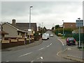
4
The A73 (Bellsfield Road) at Chapelhall
Image: © James Denham
Taken: 11 Feb 2012
0.25 miles