IMAGES TAKEN NEAR TO
Bank View, AIRDRIE, ML6 8UB
Introduction
This page details the photographs taken nearby to Bank View, ML6 8UB by members of the Geograph project.
The Geograph project started in 2005 with the aim of publishing, organising and preserving representative images for every square kilometre of Great Britain, Ireland and the Isle of Man.

There are currently over 7.5m images from over14,400 individuals and you can help contribute to the project by visiting https://www.geograph.org.uk
Image Map
Images are licensed for reuse under creativecommons.org/licenses/by-sa/2.0
Notes
- Clicking on the map will re-center to the selected point.
- The higher the marker number, the further away the image location is from the centre of the postcode.
Image Listing (4 Images Found)
Images are licensed for reuse under creativecommons.org/licenses/by-sa/2.0
Image
Details
Distance
1
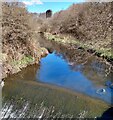
North Calder: Upstream from weir
Pier from former viaduct visible
Image: © Jim Smillie
Taken: 12 Apr 2021
0.17 miles
2
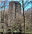
Pier of old viaduct
Carried the Airdrie-Newhouse line over the North Calder
Image: © Jim Smillie
Taken: 12 Apr 2021
0.17 miles
3
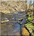
North Calder
Flowing between Chapelhall and Calderbank
Image: © Jim Smillie
Taken: 12 Apr 2021
0.20 miles