IMAGES TAKEN NEAR TO
Hawthorn Drive, AIRDRIE, ML6 8AR
Introduction
This page details the photographs taken nearby to Hawthorn Drive, ML6 8AR by members of the Geograph project.
The Geograph project started in 2005 with the aim of publishing, organising and preserving representative images for every square kilometre of Great Britain, Ireland and the Isle of Man.

There are currently over 7.5m images from over14,400 individuals and you can help contribute to the project by visiting https://www.geograph.org.uk
Image Map
Images are licensed for reuse under creativecommons.org/licenses/by-sa/2.0
Notes
- Clicking on the map will re-center to the selected point.
- The higher the marker number, the further away the image location is from the centre of the postcode.
Image Listing (9 Images Found)
Images are licensed for reuse under creativecommons.org/licenses/by-sa/2.0
Image
Details
Distance
1
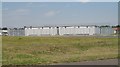
Compound, Petersburn Road
Heavily fortified enclosure across the road from New Broomfield football ground.
Image: © Richard Webb
Taken: 25 Jul 2008
0.20 miles
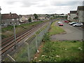
2
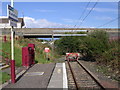
End of the Line - Drumgelloch Station
The end of the railway line through Coatbridge and Airdrie.
Image: © Chris Upson
Taken: 20 Aug 2006
0.20 miles
4
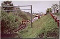
Drumgelloch 1st railway station, Lanarkshire, 2004
Opened by British Rail in 1989 as the terminus of the line from Glasgow, this station closed in 2010 when the line was reopened through to Bathgate. View west towards Airdrie and Glasgow. Ten years later, the site looked like Image
A new Drumgelloch station was opened in 2010 close to the site of what had previously been Clarkston station, some 500m closer to Edinburgh, behind the camera position.
Image: © Nigel Thompson
Taken: 15 May 2004
0.24 miles
5
Drumgelloch 1st railway station (site), Lanarkshire
Opened by British Rail in 1989 as the terminus of the line from Glasgow, this station closed in 2010 when the line was reopened through to Bathgate. View west towards Airdrie and Glasgow. Taken from slightly higher than Image
A new Drumgelloch station was opened in 2010 close to the site of what had previously been Clarkston station, some 500m closer to Edinburgh, behind the camera position.
Image: © Nigel Thompson
Taken: 5 Jul 2014
0.24 miles
6
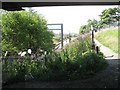
For now, the end of the line
Drumgelloch station, and the end of the working railway. The line used to run to Edinburgh via Bathgate. In 2008 work started on reopening the railway and restoring a fourth route between Edinburgh and Glasgow.
Image: © Richard Webb
Taken: 25 Jul 2008
0.24 miles
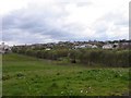
7
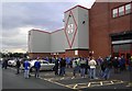
Broomfield Park
Airdrie United's Broomfield Park hosts the Queen of the South v FC Nordsjaelland UEFA cup first leg tie. It was the first that the Doonhamers had qualified for Europe but Palmerston Park was not up to UEFA standards, hence the switch of venues. Nordsjaelland won 2-1.
Image: © Colin Kinnear
Taken: 14 Aug 2008
0.24 miles
8

Millennium milepost, Drumgelloch Station
National Cycle Route 75.
Image: © Richard Webb
Taken: 25 Jul 2008
0.25 miles
9
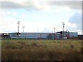
Airdrie, New Broomfield Park
Or Excelsior Stadium? Home of Airdrie United since the tragic demise of their illustrious predecessors Airdrieonians in 2002. The 'Diamonds' march on.
Image: © Robert Murray
Taken: 4 Mar 2012
0.25 miles