IMAGES TAKEN NEAR TO
Longriggend, AIRDRIE, ML6 7RT
Introduction
This page details the photographs taken nearby to ML6 7RT by members of the Geograph project.
The Geograph project started in 2005 with the aim of publishing, organising and preserving representative images for every square kilometre of Great Britain, Ireland and the Isle of Man.

There are currently over 7.5m images from over14,400 individuals and you can help contribute to the project by visiting https://www.geograph.org.uk
Image Map
Images are licensed for reuse under creativecommons.org/licenses/by-sa/2.0
Notes
- Clicking on the map will re-center to the selected point.
- The higher the marker number, the further away the image location is from the centre of the postcode.
Image Listing (4 Images Found)
Images are licensed for reuse under creativecommons.org/licenses/by-sa/2.0
Image
Details
Distance
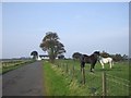
1
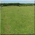
Pasture beside Longriggend Road
Closely cropped by the sheep. Evidence of mining in corner of field.
Image: © Jim Smillie
Taken: 22 Jun 2021
0.10 miles
2
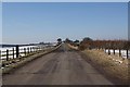
Longriggend Road
With Longrigg Lodge in the distance.
Image: © Texas Radio and The Big Beat
Taken: 10 Mar 2010
0.20 miles
3
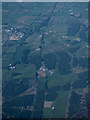
Longrigg and Smamannan from the air
Longrig is at the bottom of the photo, Smamannan is on the left. The course of the former Slamannan Railway https://en.wikipedia.org/wiki/Slamannan_Railway can be seen running vertically through the photo.
Image: © Thomas Nugent
Taken: 5 Jun 2016
0.20 miles