IMAGES TAKEN NEAR TO
York Gardens, AIRDRIE, ML6 7HH
Introduction
This page details the photographs taken nearby to York Gardens, ML6 7HH by members of the Geograph project.
The Geograph project started in 2005 with the aim of publishing, organising and preserving representative images for every square kilometre of Great Britain, Ireland and the Isle of Man.

There are currently over 7.5m images from over14,400 individuals and you can help contribute to the project by visiting https://www.geograph.org.uk
Image Map
Images are licensed for reuse under creativecommons.org/licenses/by-sa/2.0
Notes
- Clicking on the map will re-center to the selected point.
- The higher the marker number, the further away the image location is from the centre of the postcode.
Image Listing (4 Images Found)
Images are licensed for reuse under creativecommons.org/licenses/by-sa/2.0
Image
Details
Distance
1
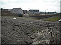
View to new estate
One of several phases of house building planned for the land belonging to the former Boots factory.
Image: © Jim Smillie
Taken: 18 Apr 2009
0.14 miles
2
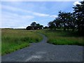
Airdrie, core path
Leads uphill to an old reservoir and open land which might be developed as a path network.
Image: © Robert Murray
Taken: 4 Jul 2011
0.16 miles
3
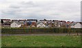
New Housing Development, Clarkston
Image: © Texas Radio and The Big Beat
Taken: 2 May 2010
0.23 miles
4
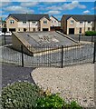
Housing development on former Boots Factory site
Panel from front of building as a memorial
Image
Image: © Jim Smillie
Taken: 14 Jul 2021
0.25 miles