IMAGES TAKEN NEAR TO
Dykehead Crescent, AIRDRIE, ML6 6PU
Introduction
This page details the photographs taken nearby to Dykehead Crescent, ML6 6PU by members of the Geograph project.
The Geograph project started in 2005 with the aim of publishing, organising and preserving representative images for every square kilometre of Great Britain, Ireland and the Isle of Man.

There are currently over 7.5m images from over14,400 individuals and you can help contribute to the project by visiting https://www.geograph.org.uk
Image Map
Images are licensed for reuse under creativecommons.org/licenses/by-sa/2.0
Notes
- Clicking on the map will re-center to the selected point.
- The higher the marker number, the further away the image location is from the centre of the postcode.
Image Listing (6 Images Found)
Images are licensed for reuse under creativecommons.org/licenses/by-sa/2.0
Image
Details
Distance
1
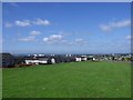
Airdrie, Thrashbush
View towards the great metropolis in the west.
Image: © Robert Murray
Taken: 26 Jul 2011
0.04 miles
2
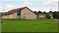
Rochsoles Community Centre
Formerly Thrashbush Football Pavilion, being in Thrashbush. Reopened in 2005.
Image: © Richard Webb
Taken: 17 Aug 2010
0.20 miles
3
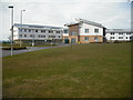
Airdrie Academy
Built on the playing fields to the NE of the old buildings. New sports facilities laid out after old building were demolished.
Image: © Jim Smillie
Taken: 29 Mar 2009
0.20 miles
4
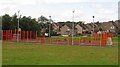
Court, Rochsoles Community Centre
A typical toughened, football and basketball court.
Image: © Richard Webb
Taken: 17 Aug 2010
0.24 miles
5
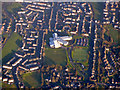
Airdrie Academy from the air
In the Thrashbush area of Airdrie.
Image: © Thomas Nugent
Taken: 8 Dec 2017
0.24 miles
6

The Church of Jesus Christ of Latter-day Saints
On Glenmavis Road (B802).
Image: © G Laird
Taken: 20 Jun 2012
0.24 miles