IMAGES TAKEN NEAR TO
Chapel Street, AIRDRIE, ML6 6LD
Introduction
This page details the photographs taken nearby to Chapel Street, ML6 6LD by members of the Geograph project.
The Geograph project started in 2005 with the aim of publishing, organising and preserving representative images for every square kilometre of Great Britain, Ireland and the Isle of Man.

There are currently over 7.5m images from over14,400 individuals and you can help contribute to the project by visiting https://www.geograph.org.uk
Image Map
Images are licensed for reuse under creativecommons.org/licenses/by-sa/2.0
Notes
- Clicking on the map will re-center to the selected point.
- The higher the marker number, the further away the image location is from the centre of the postcode.
Image Listing (26 Images Found)
Images are licensed for reuse under creativecommons.org/licenses/by-sa/2.0
Image
Details
Distance
1
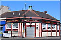
Flats in Chapel Street
Viewed from Chapel Lane, the exit from one of Airdrie's almost hidden car parks.
Image: © Anne Burgess
Taken: 10 Jul 2014
0.03 miles
3
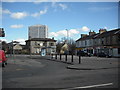
East High Street
A view of East High Street Airdrie with the Milton Court tower block behind.
Image: © Jim Smillie
Taken: 29 Mar 2009
0.13 miles
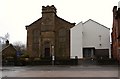
4
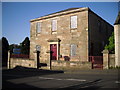
Airdrie Reformed Presbyterian Church
The year 1838 can be seen below the top middle window.
Image: © Stevie Spiers
Taken: 12 May 2009
0.14 miles
5
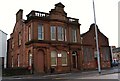
Scottish Children's Reporter
North Bridge Street.
Listed building built 1893.
Image: © Texas Radio and The Big Beat
Taken: 28 Feb 2010
0.15 miles
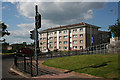
6
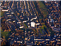
Airdrie from the air
The towerblock is Milton Court, which is reserved for people over 60 years of age http://www.housingcare.org/housing-care/facility-info-160709-milton-court-airdrie-scotland.aspx .
Image: © Thomas Nugent
Taken: 8 Dec 2017
0.15 miles
7
2 East High Street, Airdrie
South Bridge Street frontage http://portal.historicenvironment.scot/designation/LB48549
Image: © Jonathan Thacker
Taken: 20 Feb 2020
0.17 miles
8
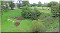
Burn course, Airdrie
Parkland with a culverted burn at the bottom of a steep sided valley. The defile is crossed by Glenmavis Road.
Image: © Richard Webb
Taken: 17 Aug 2010
0.17 miles
9
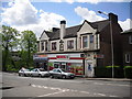
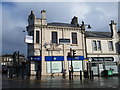
Former Co-op building
This building used to be the home of my local Co-op mini market when i was a child. This view is from Quarry Road in Airdrie.
Image: © Stevie Spiers
Taken: 22 May 2009
0.17 miles