IMAGES TAKEN NEAR TO
Park Crescent, AIRDRIE, ML6 0JD
Introduction
This page details the photographs taken nearby to Park Crescent, ML6 0JD by members of the Geograph project.
The Geograph project started in 2005 with the aim of publishing, organising and preserving representative images for every square kilometre of Great Britain, Ireland and the Isle of Man.

There are currently over 7.5m images from over14,400 individuals and you can help contribute to the project by visiting https://www.geograph.org.uk
Image Map
Images are licensed for reuse under creativecommons.org/licenses/by-sa/2.0
Notes
- Clicking on the map will re-center to the selected point.
- The higher the marker number, the further away the image location is from the centre of the postcode.
Image Listing (6 Images Found)
Images are licensed for reuse under creativecommons.org/licenses/by-sa/2.0
Image
Details
Distance
1
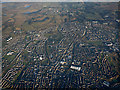
Airdrie from the air
The town centre is in the foreground. New Broomfield Park, home of Airdieonians FC https://www.airdriefc.com/ , is on the right.
Image: © Thomas Nugent
Taken: 8 Dec 2017
0.13 miles
2
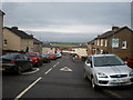
Whinhall from top of Park St. Brae
60 years ago I used to run down here to the bottom of Park St. and Manor drive on the way home from school. I was picking up grandchildren and all the cars there were on the school run.
Image: © Sarah McGuire
Taken: 30 Jan 2009
0.16 miles
3
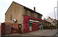
Whinhall Convenience Store
Image: © Texas Radio and The Big Beat
Taken: 2 May 2010
0.17 miles
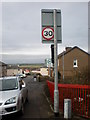
4
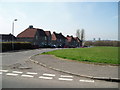
Leaend Road Airdrie
Looking southwest from Whinhall Road
Image: © Gordon Dowie
Taken: 12 Apr 2010
0.22 miles
6

Park Street, Whinhall
Park Street from the open space to the north.
Image: © Richard Webb
Taken: 17 Aug 2010
0.23 miles