IMAGES TAKEN NEAR TO
Kintyre Drive, COATBRIDGE, ML5 5JR
Introduction
This page details the photographs taken nearby to Kintyre Drive, ML5 5JR by members of the Geograph project.
The Geograph project started in 2005 with the aim of publishing, organising and preserving representative images for every square kilometre of Great Britain, Ireland and the Isle of Man.

There are currently over 7.5m images from over14,400 individuals and you can help contribute to the project by visiting https://www.geograph.org.uk
Image Map
Images are licensed for reuse under creativecommons.org/licenses/by-sa/2.0
Notes
- Clicking on the map will re-center to the selected point.
- The higher the marker number, the further away the image location is from the centre of the postcode.
Image Listing (11 Images Found)
Images are licensed for reuse under creativecommons.org/licenses/by-sa/2.0
Image
Details
Distance
2
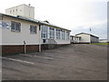
Kirkshaws Primary and Nursery School
On Old Monkland Road.
Image: © G Laird
Taken: 29 Jan 2011
0.21 miles
3
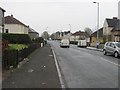
Woodside Road
View southwards from outside M. Hanif Superstore.
Image: © Richard Webb
Taken: 23 Apr 2010
0.21 miles
4
Statue in Coatbridge
Of a young boy working, no doubt in memory of what youngsters went through in the past in this traditionally industrial area.
Image: © Stephen Sweeney
Taken: 5 Mar 2008
0.22 miles

6
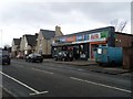
Shops in Coatbridge
On Woodside Street, Kirkwood.
Image: © Stephen Sweeney
Taken: 5 Mar 2008
0.23 miles

8
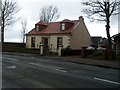
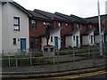
House in Coatbridge
On Woodside Street.
Image: © Stephen Sweeney
Taken: 5 Mar 2008
0.23 miles
9
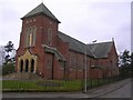
Church of St James the Greater, Kirkshaws, Coatbridge
Image: © Chris Upson
Taken: 26 Mar 2006
0.23 miles
10
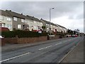
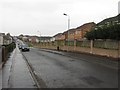
Flats on Kirkshaws Road, Coatbridge
Looking east along houses on the north side of the road.
Image: © Stephen Sweeney
Taken: 5 Mar 2008
0.25 miles