IMAGES TAKEN NEAR TO
Dunure Street, COATBRIDGE, ML5 5DN
Introduction
This page details the photographs taken nearby to Dunure Street, ML5 5DN by members of the Geograph project.
The Geograph project started in 2005 with the aim of publishing, organising and preserving representative images for every square kilometre of Great Britain, Ireland and the Isle of Man.

There are currently over 7.5m images from over14,400 individuals and you can help contribute to the project by visiting https://www.geograph.org.uk
Image Map
Images are licensed for reuse under creativecommons.org/licenses/by-sa/2.0
Notes
- Clicking on the map will re-center to the selected point.
- The higher the marker number, the further away the image location is from the centre of the postcode.
Image Listing (8 Images Found)
Images are licensed for reuse under creativecommons.org/licenses/by-sa/2.0
Image
Details
Distance
1
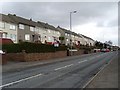
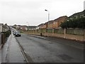
Flats on Kirkshaws Road, Coatbridge
Looking east along houses on the north side of the road.
Image: © Stephen Sweeney
Taken: 5 Mar 2008
0.13 miles
2
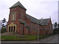
Church of St James the Greater, Kirkshaws, Coatbridge
Image: © Chris Upson
Taken: 26 Mar 2006
0.13 miles
3
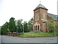
Church of St James the Greater, Kirkshaws, Coatbridge
Image: © Elliott Simpson
Taken: 13 Sep 2012
0.17 miles
4
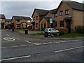
Carmyle Gardens, Coatbridge
New housing development just off Kirkshaws Road.
Image: © Stephen Sweeney
Taken: 5 Mar 2008
0.18 miles
5
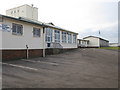
Kirkshaws Primary and Nursery School
On Old Monkland Road.
Image: © G Laird
Taken: 29 Jan 2011
0.21 miles
7
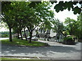
Kirkstyle Cottages, Coatbridge
On Kirkshaws Road.
Image: © Stephen Sweeney
Taken: 5 Mar 2008
0.24 miles
8
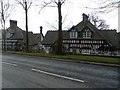
Kirkstyle Cottages
These cottages beside Old Monkland church date from 1904.
Image: © Jim Smillie
Taken: 15 Jun 2010
0.24 miles