IMAGES TAKEN NEAR TO
Peebles Path, COATBRIDGE, ML5 4TJ
Introduction
This page details the photographs taken nearby to Peebles Path, ML5 4TJ by members of the Geograph project.
The Geograph project started in 2005 with the aim of publishing, organising and preserving representative images for every square kilometre of Great Britain, Ireland and the Isle of Man.

There are currently over 7.5m images from over14,400 individuals and you can help contribute to the project by visiting https://www.geograph.org.uk
Image Map (Loading...)


Getting Data...Please wait
Leaflet Map data © OpenStreetMap
Images are licensed for reuse under creativecommons.org/licenses/by-sa/2.0
Notes
- Clicking on the map will re-center to the selected point.
- The higher the marker number, the further away the image location is from the centre of the postcode.
Image Listing (8 Images Found)
Images are licensed for reuse under creativecommons.org/licenses/by-sa/2.0
Image
Details
Distance
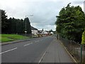
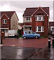
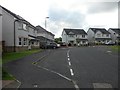
2
Brambling Road, Carnbroe
New estate in the Lanarkshire village.
Image: © Stephen Sweeney
Taken: 22 Aug 2012
0.07 miles
6
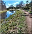
Monkland Canal
Part of North Calder Heritage Trail
Image: © Jim Smillie
Taken: 12 Apr 2021
0.21 miles
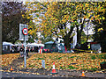
7
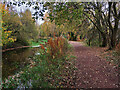
Monkland Canal near Carnbroe
The Palacecraig Brick Works was on the far side of the canal.
Image: © wrobison
Taken: 26 Oct 2024
0.22 miles
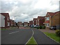
8
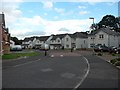
Redwing Crescent, Carnbroe
New housing estate, not marked even on the 2005 OS map.
Image: © Stephen Sweeney
Taken: 22 Aug 2012
0.24 miles