IMAGES TAKEN NEAR TO
Greenwood Crescent, COATBRIDGE, ML5 4RH
Introduction
This page details the photographs taken nearby to Greenwood Crescent, ML5 4RH by members of the Geograph project.
The Geograph project started in 2005 with the aim of publishing, organising and preserving representative images for every square kilometre of Great Britain, Ireland and the Isle of Man.

There are currently over 7.5m images from over14,400 individuals and you can help contribute to the project by visiting https://www.geograph.org.uk
Image Map
Images are licensed for reuse under creativecommons.org/licenses/by-sa/2.0
Notes
- Clicking on the map will re-center to the selected point.
- The higher the marker number, the further away the image location is from the centre of the postcode.
Image Listing (7 Images Found)
Images are licensed for reuse under creativecommons.org/licenses/by-sa/2.0
Image
Details
Distance
1
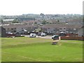
Shiel Place, Coatbridge
View from the cycle path on an old railway.
Image: © Richard Webb
Taken: 25 Jul 2008
0.19 miles
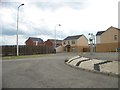
3
New road, Green End
A new road and its associated construction site. View from Paddock Street, Sikeside.
Image: © Richard Webb
Taken: 22 Jan 2010
0.22 miles
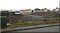
5
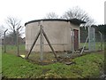
Pumping station, Sikeside
Water pumping station off Paddock Street.
Image: © Richard Webb
Taken: 22 Jan 2010
0.24 miles
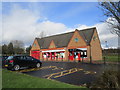
6
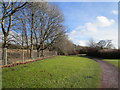
North Calder Heritage Trail
Broadly follows the line of the Monkland Canal.
Image: © Jonathan Thacker
Taken: 20 Feb 2020
0.24 miles
7
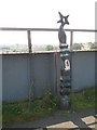
National Cycle Network milepost
Milepost on a viaduct. The former railway has been converted into a cycle path.
Image: © Richard Webb
Taken: 25 Jul 2008
0.25 miles