1
Grassland off Carnbroe Road
Wet field after snowmelt. Cattle were grazing here before the snow.
Image: © Richard Webb
Taken: 22 Jan 2010
0.05 miles
2
Grassland off Carnbroe Road
Heavily poached field in quite a muddy state after snowmelt. View past a loch unnamed on the maps, towards Eurocentral. The A8 is all too clearly within earshot.
Image: © Richard Webb
Taken: 22 Jan 2010
0.11 miles
3
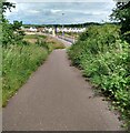
Footpath/Cycle path beside Carnbroe Road
New housing development under construction
Image: © Jim Smillie
Taken: 6 Jul 2021
0.13 miles
4
Redwing Crescent, Carnbroe
New housing estate, not marked even on the 2005 OS map.
Image: © Stephen Sweeney
Taken: 22 Aug 2012
0.15 miles
5
Layby, Carnbroe Road
Beyond the usual mucky layby - or rubbish bin for certain fast food companies, is what appears to be an old road. The muddy way between two fences leads to a small loch. Could be mining subsidence, surface workings or even natural.
The chevrons are printed on what looks a bit like guttering, made of parallel strips of a plastic, probably P.V.C.
Image: © Richard Webb
Taken: 22 Jan 2010
0.16 miles
6
A hedgerow in a field
This is actually the track-bed of one of the many railways which are typical of the former industrial areas of Scotland.
What would the men, who laboured so hard to open up the country for the new rail links, have thought if they'd known it would end up as a wild-life habitate?
Image: © Elliott Simpson
Taken: 9 Jun 2007
0.18 miles
7
Old railway, Carnbroe Road
Hawthorn marks the site of a mineral line, long since closed. The railway does not appear on maps from the 1940s.
Image: © Richard Webb
Taken: 22 Jan 2010
0.18 miles
8
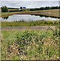
Balancing Pond
Between Carnbroe Road and A8
Image: © Jim Smillie
Taken: 6 Jul 2021
0.20 miles
9
Sandpiper Crescent, Carnbroe
Image: © Stephen Sweeney
Taken: 22 Aug 2012
0.21 miles
10
Carnbroe Road
Looking southwards towards the junction with the A8.
Image: © Richard Webb
Taken: 22 Jan 2010
0.21 miles


