IMAGES TAKEN NEAR TO
Grannoch Place, COATBRIDGE, ML5 4BF
Introduction
This page details the photographs taken nearby to Grannoch Place, ML5 4BF by members of the Geograph project.
The Geograph project started in 2005 with the aim of publishing, organising and preserving representative images for every square kilometre of Great Britain, Ireland and the Isle of Man.

There are currently over 7.5m images from over14,400 individuals and you can help contribute to the project by visiting https://www.geograph.org.uk
Image Map (Loading...)


Getting Data...Please wait
Leaflet Map data © OpenStreetMap
Images are licensed for reuse under creativecommons.org/licenses/by-sa/2.0
Notes
- Clicking on the map will re-center to the selected point.
- The higher the marker number, the further away the image location is from the centre of the postcode.
Image Listing (2 Images Found)
Images are licensed for reuse under creativecommons.org/licenses/by-sa/2.0
Image
Details
Distance
1
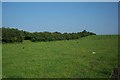
A hedgerow in a field
This is actually the track-bed of one of the many railways which are typical of the former industrial areas of Scotland.
What would the men, who laboured so hard to open up the country for the new rail links, have thought if they'd known it would end up as a wild-life habitate?
Image: © Elliott Simpson
Taken: 9 Jun 2007
0.24 miles