IMAGES TAKEN NEAR TO
Cecil Street, COATBRIDGE, ML5 4AJ
Introduction
This page details the photographs taken nearby to Cecil Street, ML5 4AJ by members of the Geograph project.
The Geograph project started in 2005 with the aim of publishing, organising and preserving representative images for every square kilometre of Great Britain, Ireland and the Isle of Man.

There are currently over 7.5m images from over14,400 individuals and you can help contribute to the project by visiting https://www.geograph.org.uk
Image Map (Loading...)


Getting Data...Please wait
Leaflet Map data © OpenStreetMap
Images are licensed for reuse under creativecommons.org/licenses/by-sa/2.0
Notes
- Clicking on the map will re-center to the selected point.
- The higher the marker number, the further away the image location is from the centre of the postcode.
Image Listing (7 Images Found)
Images are licensed for reuse under creativecommons.org/licenses/by-sa/2.0
Image
Details
Distance
1
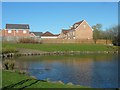
Luggieburn Walk
New housing development in Coatbridge, North Lanarkshire.
Image: © Stephen Sweeney
Taken: 18 Apr 2012
0.19 miles
2
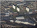
Coatbridge from the air
Faraday retail park is in the foreground.
Image: © Thomas Nugent
Taken: 9 Feb 2018
0.21 miles
3
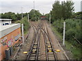
Whifflet Upper and Lower railway station (site), North Lanarkshire
Whifflet Upper was situated on the red bridge. It was opened as a single island platform in 1886 by the Rutherglen and Coatbridge Railway, soon to become part of the Caledonian Railway, and closed to passengers in 1964.
Beneath it, situated on either side of the tracks were the platforms of Whifflet Lower station, also Caledonian Railway. (Out of view to the right, the North British Railway also had a station from 1871 to 1930. No evidence of this appears to remain).
View north towards Coatbridge and Cumbernauld. The tracks diverging left lead to Glasgow Central via Carmyle.
Image: © Nigel Thompson
Taken: 12 Oct 2013
0.22 miles
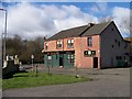
5
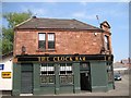
The Clock Bar
Pub, Burnside Court, Coatbridge.
Image: © Richard Webb
Taken: 25 Jul 2008
0.23 miles
6
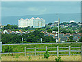
High Coats towerblocks
The cluster of three towerblocks appear as one when viewed from the two miles distant Eurocentral Junction 7 above the M8 motorway.
Image: © Thomas Nugent
Taken: 2 Aug 2020
0.24 miles
7
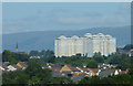
High Coats towerblocks
The cluster of three towerblocks appear as one when viewed from the two miles distant Eurocentral Junction 7 at the M8 motorway.
Image: © Thomas Nugent
Taken: 9 Aug 2020
0.24 miles