IMAGES TAKEN NEAR TO
Exeter Street, COATBRIDGE, ML5 4AH
Introduction
This page details the photographs taken nearby to Exeter Street, ML5 4AH by members of the Geograph project.
The Geograph project started in 2005 with the aim of publishing, organising and preserving representative images for every square kilometre of Great Britain, Ireland and the Isle of Man.

There are currently over 7.5m images from over14,400 individuals and you can help contribute to the project by visiting https://www.geograph.org.uk
Image Map (Loading...)


Getting Data...Please wait
Leaflet Map data © OpenStreetMap
Images are licensed for reuse under creativecommons.org/licenses/by-sa/2.0
Notes
- Clicking on the map will re-center to the selected point.
- The higher the marker number, the further away the image location is from the centre of the postcode.
Image Listing (5 Images Found)
Images are licensed for reuse under creativecommons.org/licenses/by-sa/2.0
Image
Details
Distance
1
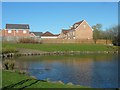
Luggieburn Walk
New housing development in Coatbridge, North Lanarkshire.
Image: © Stephen Sweeney
Taken: 18 Apr 2012
0.14 miles
3
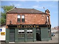
The Clock Bar
Pub, Burnside Court, Coatbridge.
Image: © Richard Webb
Taken: 25 Jul 2008
0.18 miles
4
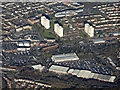
Coatbridge from the air
Faraday retail park is in the foreground.
Image: © Thomas Nugent
Taken: 9 Feb 2018
0.24 miles
5

National Cycle Network milepost
Railway fence in background.
Image: © Richard Webb
Taken: 25 Jul 2008
0.24 miles